
Existed: 1993 – present Constructed 1993 | Length 37.01 km | |
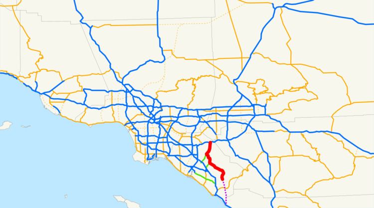 | ||
South end: Oso Parkway near Rancho Santa Margarita North end: SR 91 in Anaheim / Yorba Linda | ||
State Route 241 (SR 241) is a state highway in the U.S. state of California. For its entire run, Route 241 is a toll road. Its northern half is part of the Eastern Transportation Corridor while its southern half is part of the Foothill Transportation Corridor.
Contents
Map of CA-241, California, USA
The highway currently runs from Rancho Santa Margarita to Yorba Linda. Route 241 connects with State Route 133, State Route 261, and State Route 91.
Route description
This route is part of the California Freeway and Expressway System.
The Foothill Toll Road (also called The Foothill Transportation Corridor) is a 12-mile (19 km) tollway in Orange County. Signed as State Route 241, it travels parallel to Interstate 5, connecting the Eastern Toll Road (at the State Route 133/State Route 241 interchange) outside of Irvine with Oso Parkway near Mission Viejo.
The toll road was constructed by the Transportation Corridor Agencies, also known as the TCA, and is owned by the state of California. Construction was financed with bonds, which are repaid with toll revenues. Taxpayers are not responsible for repaying any debt if toll revenues fall short.
The route begins at Oso Parkway near Rancho Santa Margarita and heads northward. The toll road enters Rancho Santa Margarita, crossing El Toro Road without an exit. Heading north, SR 241 passes through Irvine before meeting SR 133, another toll road. The freeway meets SR 261 near Irvine Lake before turning northeastward. SR 241 meets its terminus at SR 91 near the Santa Ana River.
Future
Foothill-South was planned as the last segment of the road, and the final piece in Orange County's planned 67-mile (108 km) network of public toll roads. It has been the subject of regional planning efforts for the more than 20 years.
The extension would provide an alternate route to Interstate 5 for those traveling from Riverside, Corona and southeast Orange County to points southward as well as those traveling from North San Diego County northward. Proponents of the project, including a coalition of chambers of commerce, argue it would provide greater access for communities such as Foothill Ranch, Rancho Santa Margarita, Las Flores, Coto de Caza, Wagon Wheel and the future Rancho Mission Viejo. The TCA Board of Directors, local elected officials who represent the areas adjacent to the toll road routes, certified the project's Environmental Impact Report in 2006.
The route was selected by a collaborative group that included the Federal Highway Administration, Environmental Protection Agency, Fish & Wildlife Service, the Army Corps of Engineers and Caltrans.
The route would extend the toll road to connect to Interstate 5 at the San Diego County line near San Onofre, where the TCA projects traffic to increase 60 percent by 2025. The final four miles (6 km) of the roadway would be located on Camp Pendleton Marine Base. The road would go through a section of the San Onofre State Park, which is leased from the United States Marine Corps. The Marine Corps reserved the right to grant easements for rights of way when the lease with the California Department of Parks and Recreation was signed in 1971.
The TCA estimates that by 2025, Foothill-South would carry 58,000 vehicles per day. This would represent about 13% of the estimated 460,000 cars per day on the I-5 by that time.
On February 6, 2008, the California Coastal Commission voted 8-2 to reject a 16-mile (26 km) southern segment of the 241, Foothill-South, which was planned for the Foothill Toll Road. The TCA appealed the Coastal Commission's decision to the U.S. Secretary of Commerce. On December 18, 2008, the Department of Commerce announced that it would uphold the California Coastal Commission’s ruling that found the TCA’s proposed extension of the 241 Toll Road inconsistent with the California Coastal Act. In a release issued by the Department of Commerce, the DOC noted that at least one reasonable alternative to the project existed, and that the project was not necessary in the interest of national security.
Environment
The extension is opposed by many conservationists, environmental groups, and residents of San Clemente. Former California Attorney General Bill Lockyer filed two lawsuits in 2006, one on behalf of the Native American Heritage Commission. A third lawsuit was filed by a coalition of several groups, including Sierra Club, the Surfrider Foundation, Natural Resources Defense Council.
One area of concern for those opposed is how well the project will avoid Native American sites in the area, such as the ancient Acjachemen village of Panhe. The TCA asserts it will avoid these sites, but this is disputed by opponents. The road as conceived would bridge over San Mateo Creek as the existing Interstate 5, old Highway 101 and train tracks currently do.
Opponents of the proposed extension are also concerned about possible damage to water quality, and the disruption of wave quality at Trestles, a world-famous surfing spot. In response, the TCA claims that mitigation techniques will eliminate any negative effect on water quality, and that the proposed detention basins will in addition capture runoff from a two-mile (3 km) portion of the I-5 which is currently untreated. Studies have determined that there will be no effect on wave quality at Trestles. The independence of all these studies is in dispute.
Traffic
The project's opponents also contend that the expansion would not provide significant rush-hour traffic relief as it does not connect the communities of southeast Orange County to any major job centers. In addition, opponents claim that the expansion would draw a portion of its traffic from Interstate 15, twenty-five miles further inland, even though the Foothill Toll Road would run at near right-angles with Interstate 15, which runs through Temecula and leads to Corona, California.
Another concern of the project's opponents is the non-compete clause which the TCA has signed with the California Department of Transportation, or Caltrans. The clause requires Caltrans to compensate the TCA for lost revenue caused by highway improvements which might compete with the tollways, thereby reducing toll revenue. The clause expires in 2020. Opponents of the expansion argue that the non-compete clause makes improvements to Interstate 5 highly unlikely until at least 2020. In response to this, the TCA claims that traffic removed from the I-5 by the addition of Foothill-South will reduce congestion on the I-5 without the need for additional upgrades. However, it has been shown in traffic studies that extending SR 241 to connect with Interstate 5 would actually increase the traffic on Interstate 5 within southern Orange County and northern San Diego County. Additionally, the non-compete clause does not apply to any improvements which have already been specified by the OCTA in Measure M transportation funds.
An alternate route for Foothill-South has been proposed by opponents of the San Onofre-bound extension. The "beltway" alternative would continue south past Oso Parkway as planned but would then turn westward north of Ortega Highway and continue between the communities of San Juan Capistrano and Ladera Ranch before meeting Interstate 5 and California State Route 73 in southwest Mission Viejo. Proponents claim that this alignment will connect residential areas in Southeast Orange County to job centers to the Northwest through Route 73, while also alleviating congestion on Interstate 5 from San Juan Capistrano to Irvine. However, proponents acknowledge that a widening of Interstate 5 south of the beltway interchange would be necessary to alleviate congestion south of Mission Viejo. The U.S. Federal Highway Administration conducted an analysis of the project opponents' I-5 widening plan (known as "Smart Mobility") and deemed it "not reasonable and feasible." Caltrans Director Will Kempton stated at the February 2008 Coastal Commission meeting that the opponents' Smart Mobility plan to widen I-5 "did not comply with our (Caltrans) design standards. Safety issues were not considered."
As an alternative to Foothill-South, opponents generally argue that transportation dollars should be spent on a major upgrade to Interstate 5, and on improving mass transit in the area, such as the existing Metrolink line which terminates at Oceanside. Kempton went on to say, “We cannot compromise safety in the construction of our transportation infrastructure.” The U.S. Federal Highway Administration and Caltrans agree that widening the I-5 would cost more than $2.5 billion and would result in the demolition of more than 1,000 homes and businesses.
Tolls
SR 241 employs a barrier toll system, where drivers are charged flat-rate tolls based on what particular mainline toll booths, on-ramps, or off-ramps they pass through. There are two mainline toll booths: the Tomato Springs Toll Plaza just south of the SR 133 interchange, and the Windy Ridge Toll Plaza to the south of the SR 91 interchange.
Since May 13, 2014, the road has been using an all-electronic, open road tolling system; cash is no longer being accepted. Drivers may pay using the FasTrak electronic toll collection system, license plate tolling (under Transportation Corridor Agencies's brand name "ExpressAccount"), or via a one time payment online. Those using Fastrak are charged a lower toll than those using the other two methods. Drivers must pay within 5 days after their trip on the toll road or they will assessed a toll violation.
The following table lists the tolls at each of the tolled exits for passenger cars and other two-axle vehicles (as of July 1, 2015). Vehicles with more than two axles pay a higher toll at the two mainline toll plazas.
Exit list
Except where prefixed with a letter, postmiles were measured on the road as it was when the route was established, based on the alignment that existed at the time, and do not necessarily reflect current mileage. R reflects a realignment in the route since then, M indicates a second realignment, L refers an overlap due to a correction or change, and T indicates postmiles classified as temporary (for a full list of prefixes, see the list of postmile definitions). Segments that remain unconstructed or have been relinquished to local control may be omitted. The entire route is in Orange County.