
OS grid reference NY0406 Post town SEASCALE Dialling code 01946 UK parliament constituency Copeland | Sovereign state United Kingdom Postcode district CA20 District Copeland | |
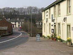 | ||
Calder Bridge (also Calderbridge) is a hamlet in Cumbria in the United Kingdom. It is located between the villages of Gosforth and Beckermet.
Map of Calder Bridge, Seascale, UK
It is around 1 mile northeast from the Sellafield nuclear plant—Calder Hall Nuclear Power Station was the world's first major nuclear power station when it opened in 1956.
The current St Bridget's Church, Calder Bridge was built in 1842.
Calder Abbey, which lies by the River Calder just northeast of Calder Bridge, is a picturesque ruin adjoining Calder Abbey House, a largely 19th-century house which incorporates some remains of the abbey.
On the south side of Calder Bridge lies the Grade II listed Pelham House (named after Herbert Pelham, 3rd bishop of Barrow-in-Furness) but formerly known as Ponsonby Hall. It was built in 1774 and was designed by James Paine for Edward Stanley. This is currently used as offices for the Nuclear Decommissioning Authority (NDA), and before this was used as a School for Boys.