
Population 3,519 (2006 census) Local time Monday 7:44 PM | Postcode(s) 2340 Postal code 2340 | |
 | ||
Weather 23°C, Wind SE at 18 km/h, 47% Humidity | ||
Callala is a suburb of the Northern New South Wales city of Tamworth, administered by Tamworth Regional Council. In the 2006 census Calala had a population of 3,519.
Contents
Map of Calala NSW 2340, Australia
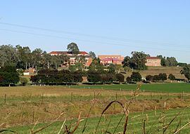
The suburb is 4.5 kilometres south from the CBD of Tamworth and is connected to the city by Callala Lane, which continues through the suburb to form its main street. Calala Lane often becomes flooded in times of heavy rain, usually isolating the residents from the rest of the city. Further along Callala Lane past Calala is Farrer Memorial Agricultural High School and the New South Wales Department of Agriculture plant research institute.
Commercial area
A new commercial shopping complex opened in 2006 which now serves the residents of Calala. The complex contains an IGA supermarket, fish and chip takeaway shop, newsagency, bottle shop, butcher, pharmacy and newsagent. Calala also contains a smaller shopping centre consisting of a bottle shop and a general store