
Listing Furth, Hewitt Topo map OSI Discovery 78 Prominence 100 m Easiest route Hiking | OSI/OSNI grid V792839 Elevation 1,001 m Mountain range Macgillycuddy's Reeks Parent range Macgillycuddy's Reeks | |
 | ||
Translation stone fort of the Fianna (Irish) Similar Beenkeragh, Carrauntoohil, Caher West Top, Cnoc na Péiste, Maolán Buí | ||
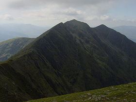
Caher (Irish: Cathair or Cathair na Féinne, meaning "stone fort of the Fianna"), also called Caher East Top, is the third-highest mountain peak in Ireland, at 1,001 metres (3,284 ft). Some sources give its height as 1,000 metres (3,281 ft).
Contents
Map of Caher, Cappanthlarig, Co. Kerry, Ireland
Geography
The mountain lies to the southwest of Carrauntoohil (Ireland's highest peak) in the MacGillycuddy's Reeks of County Kerry. It is classed as a Furth by the Scottish Mountaineering Club and is also in the list of "Irish Munros".
The summit is at grid reference V792838. Its neighbouring peaks are Caher (West Top), The Bones, Carrauntoohil, Curraghmore, Beenkeragh and Skregmore.
References
Caher (mountain) Wikipedia(Text) CC BY-SA