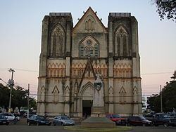
Country Brazil Area 24,398 km² Local time Tuesday 4:49 PM | Founded 6 October 1778 Population 90,881 (2016) | |
 | ||
Weather 28°C, Wind NE at 8 km/h, 81% Humidity University Mato Grosso State University | ||
Cáceres is a municipality in the Brazilian state of Mato Grosso. It covers an area of 24,000km2 and as of 2014 had an estimated population of 90,000.
Map of C%C3%A1ceres - State of Mato Grosso, Brazil
The town is sited on the Paraguay River, and hosts a popular fishing festival each September. The municipality contains part of the Serra das Araras Ecological Station. It also contains part of the Taiamã Ecological Station. The municipality contains the 114,000 hectares (280,000 acres) Guirá State Park, created in 2002.
Cáceres was the starting point of the Roosevelt–Rondon Scientific Expedition.
References
Cáceres, Mato Grosso Wikipedia(Text) CC BY-SA
