
Isolation 4.3 km (2.7 mi) Translation Bad Fulen (German) Prominence 368 m | Listing Canton high point Elevation 2,802 m | |
 | ||
Similar Ortstock, Glärnisch, Höch Turm, Pfannenstock, Tödi | ||
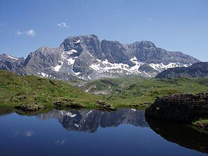
The Bös Fulen is a mountain in the Schwyz Alps, located on the border between the cantons of Schwyz and Glarus. It overlooks the valleys of Muotathal (Schwyz) and Linthal. It is the highest summit of the canton of Schwyz. Politically, it is split between the municipalities of Muotathal (Schwyz) and Glarus. Braunwald is the nearest locality.
Map of B%C3%B6s Fulen, 8750 Muotathal, Switzerland
References
Bös Fulen Wikipedia(Text) CC BY-SA