
- summer (DST) CEST (UTC+2) Local time Thursday 3:37 PM | Area 43.17 km² | |
 | ||
Weather 9°C, Wind SW at 19 km/h, 63% Humidity | ||
Bytča (Hungarian: Nagybiccse) is a town in northwestern Slovakia. It is located on the Váh River near the cities of Žilina and Považská Bystrica. It belongs to Upper Váh region of tourism.
Contents
- Map of 014 01 BytC48Da Slovakia
- History
- Landmarks
- Demographics
- Economy
- Boroughs
- Twin towns Sister cities
- Famous people
- References
Map of 014 01 Byt%C4%8Da, Slovakia
History
The town arose in 1946 by a merger of the settlements Malá Bytča (including Beňov and Mikšová), Veľká Bytča and Hliník nad Váhom. The first written reference to the town's main part Veľká Bytča dates from 1234 as terra Bycha. The settlement got its town charter in 1378. It was the seat of a feudal dominion and later a town with many craftsmen. In Hungarian, it was known as Biccse.
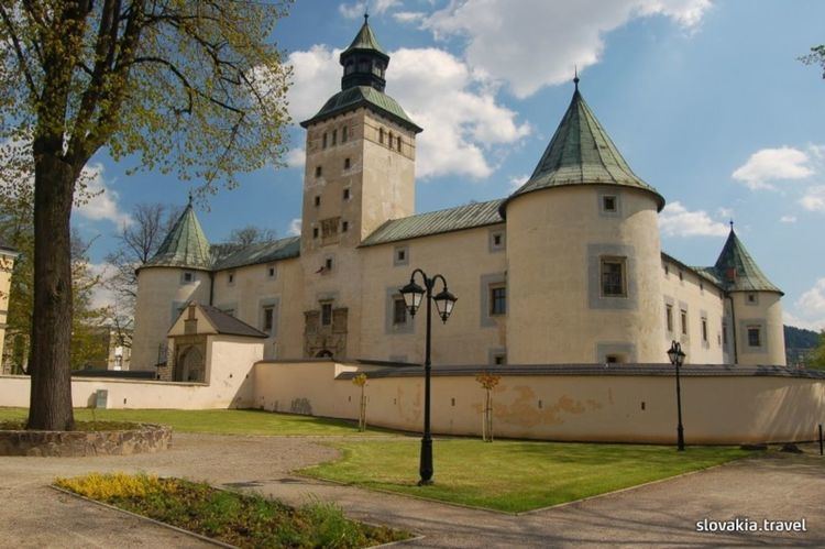
Landmarks
The town features a famous castle the Thurzó Castle built as a water castle by Pongrác Szentmiklósi in the 13th century and rebuilt in the 16th century in Renaissance style by Ferenc Thurzó. The town also houses the Wedding Palace (built by György Thurzó for his daughters' wedding) from 1601, which is the only building of this kind in Slovakia, Renaissance, Baroque and Classical bourgeoisie houses, an archive, and a museum (in the Wedding Palace).
Demographics
According to the 2001 census, the town had 11,150 inhabitants. 98.27% of inhabitants were Slovaks and 0.58% Czechs. The religious make-up was 90.87% Roman Catholics, 4.35% people with no religious affiliation and 1.51% Lutherans.
Economy
Today, the town is home to machine (Kinex), textile, wood processing (sports equipment), and food (brewery) industries.
Boroughs
Bytča includes the following former villages: Psurnovice, Hrabove, Horne Hlboke, Dolne Hlboke, Hlboke nad Vahom, Benov, Miksova, Hlinik nad Vahom, Velka Bytca, Mala Bytca.
Current boroughs (year of merger in brackets):
Twin towns — Sister cities
Bytča is twinned with: