
Basin size 2,520 km (970 sq mi) Mouth Dniester | Length 17 km Country Ukraine | |
 | ||
Main source confluence of Bystrytsia of Solotvyn and Bystrytsia of Nadvirna (near Vovchynets, Ivano-Frankivsk) River mouth Dniester River (Yezupil) Sources Bystrytsia of Solotvyn, Ivano-Frankivsk Oblast | ||
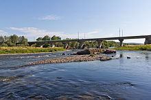
The Bystrytsia (Ukrainian: Бистриця; Polish: Bystrzyca) is a river, a right tributary of the Dniester which flows through Tysmenytsia Raion, Ivano-Frankivsk Oblast.
Contents
Map of Bystrytsya River, Ivano-Frankivska, Ukraine
Bystrytsia river is formed by confluence of Bystrytsia of Solotvyn and Bystrytsia of Nadvirna.
Formation and course
The Bystrytsia-Nadvirnyanska, a typical mountain river; in its lower course (Subcarpathia), a river of the plains, has a length of 94 km (58 mi) and a drainage basin of 1,580 km2 (610 sq mi), and the Bystrytsia-Solotvynska half has a length of 82 km (51 mi) and a drainage basin of 795 km2 (307 sq mi).
Both of the branches, typical mountain rivers, of the Bystrytsia river take their sourch in the Gorgany Mountains of the Carpathian mountain range in the Ukrainian province of Ivano-Frankivsk. With the city of Ivano-Frankivsk, the administrative center of the Ivano-Frankivsk Oblst, the two branches merge, and then flow 17 km (11 mi) south of Halych near the town of Yezupil where the river finally flows into the Dniester.
The name, Bystrytsia, is translated as fast moving from the Slavic word, бистрий - bystry.