
Population 855 (2011) Sovereign state United Kingdom Local time Thursday 11:51 AM Dialling code 01978 | OS grid reference SJ264533 Country Wales Post town WREXHAM Ceremonial county Clwyd | |
 | ||
Weather 7°C, Wind W at 27 km/h, 70% Humidity | ||
Bwlchgwyn is a village in Wrexham county borough, Wales, on the A525 road, 5 miles (8 km) west of the town of Wrexham and 10 miles (16 km) south-east of the town of Ruthin. Bwlchgwyn is part of the community of Brymbo. In the 2011 Census the population of the village was 855.
Contents
Map of Bwlchgwyn, Brymbo, Wrexham, UK
Etymology
The placename Bwlchgwyn translates into English as "White Pass" which refers to the white limestone cliffs in the area. It has also been suggested that the original name was Bwlchgwynt meaning "Windy Pass".
The name Bwlchgwyn is also said to mean that the pass is white because it is the first and last place in the district where snow settles. Similarly, nearby Gwynfryn means "white hill".
Geography
At a height of 1,090 feet (333 m) above sea level, it claimed to be the highest village in Wales until December 2015, when it was discovered that Trefil in Blaenau Gwent is actually the highest by the Ordnance Survey. As such, the village will now be removing the signs claiming to be the highest village. As the village is so high, there is a good view of the Peak district, Frodsham Hill and the Cheshire Plain; with Jodrell Bank being seen on clear days.
Two rivers have their sources near the village: the River Gwenfro rises on the south side of the village and the Nant-y-Ffrith flows through a wooded valley to the north.
The village is built on Cefn-y-fedw sandstone, a type of Millstone Grit from the Carboniferous period. It contains veins of lead ore and various other minerals.
History
Bwlchgwyn has been inhabited since at least the Bronze Age when a hill fort was built there (now destroyed by quarrying). A small roman fort is also thought to have stood on the highest point of the village, but this too has been lost to quarrying. It is known the romans worked the shallow lead veins of the Eisteddfod, with the small fort possibly being a base for these operations. Ancient hedgerows, dating from this period can also be found opposite George Edwards and son bus depo. It has been suggested (by Ivan Margary, pioneering historian of Roman roads) that the old road up from Glascoed and along the ridge above Nant-y-Ffrith is of Roman origin: followed, from Bwlchgwyn, by today’s main road, it runs to the hamlet near Landegla called Pen-y-stryt (“the end of the road“) and then across the moors.
Until the 19th century the area was common land used for grazing with only a few houses. As with other villages in this area, such as Coedpoeth, Gwynfryn and Minera, the village prospered in the agricultural and industrial revolutions, benefiting from the rich deposit of silica underground. Local quarries and coal mines provided employment, and the village grew. The nearby Minera Limeworks was the largest employer in the area until it closed in the 1970s. In 1954 the Bwlchgwyn Silica Company even proposed to purchase the entire land of Bwlchgwyn for mining purposes and force residents to move. This plan was accepted, but after campaigns by local villagers and a councillor: Mr.Hooker, it was eventually denied and the company soon ceased to operate.
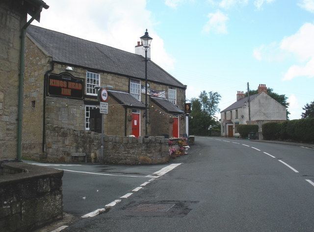
Several public houses opened in the area, one of which still remains - The King's Head Inn, seen in the photograph above. Two chapels were built in the village: the Nebo Chapel was first built in 1852 and had a peak congregation of 150. Bwlchgwyn School opened in 1875; the building stood for over 100 years before being replaced by a new school. The Welsh-language author Edward Tegla Davies was a pupil and later a teacher there. A gothic hall was situated on the top of Fron heulog hill in the late 19th and early 20th centuries; known as Fron Heulog Hall. At one time it was a hotel, much famed for the restorative properties of the clear airand patronised by film stars, at another time it was the Roseneath Girls School. In 1908 it was up for auction as Roseneath on the Hill. It was later demolished due to quarry work nearby.
Bwlchgwyn today
Today the village has its own primary school, with secondary schooling in Wrexham. The bus company George Edwards and Son is based in Bwlchgwyn. It formerly operated the village bus service but now only runs coach trips. The main road through the village is the A525 between Newcastle-under-Lyme and Rhyl. This creates a high volume of traffic through the village, although this was calmed by road improvements to a parallel route going around the village. There is a public house called The King's Head, which as of August 2013 has been run by Ray and Carole Millar.
There is a well-used community centre which is also home to the village post office, the local toddler group, an indoor bowls club, and karate club. The community centre can be found inside the park, which also includes two tennis courts which can be freely accessed by the public.
Recently, a Motor safari has been developed in the Silica quarry in Bwlchgwyn. Notably, attendees include Top Gear.