
Coat of arms Flag Selsoviets 12 Area 4,442 km² | Rural localities 34 | |
 | ||
Federal subject Republic of Bashkortostan Administrative center selo of Starosubkhangulovo | ||
Press team visit family at burzyansky district the republic of bashkortostan russia
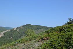
Burzyansky District (Russian: Бурзя́нский райо́н; Bashkir: Бөрйән районы) is an administrative and municipal district (raion), one of the fifty-four in the Republic of Bashkortostan, Russia. It is located in the south of the republic and borders with Beloretsky District in the north, Abzelilovsky District in the east, Baymaksky District in the southeast, Zilairsky District in the south, Kugarchinsky District in the southwest, Meleuzovsky District in the west, and with Ishimbaysky District in the west and northwest. The area of the district is 4,444 square kilometers (1,716 sq mi). Its administrative center is the rural locality (a selo) of Starosubkhangulovo. As of the 2010 Census, the total population of the district was 16,698, with the population of Starosubkhangulovo accounting for 27.6% of that number.
Contents
- Press team visit family at burzyansky district the republic of bashkortostan russia
- Map of Burzyansky District Republic of Bashkortostan Russia
- History
- Administrative and municipal status
- References
Map of Burzyansky District, Republic of Bashkortostan, Russia
History
The district was first established on August 20, 1930. It was merged into Beloretsky Rural District on February 1, 1963, but was restored on November 4, 1965.
The Bashkirsky Nature Reserve (a 'zapovednik' strict nature reserve) is located in District, covering mountainous territory of the Kaga River.
Administrative and municipal status
Within the framework of administrative divisions, Burzyansky District is one of the fifty-four in the Republic of Bashkortostan. The district is divided into twelve selsoviets, comprising thirty-four rural localities. As a municipal division, the district is incorporated as Burzyansky Municipal District. Its twelve selsoviets are incorporated as twelve rural settlements within the municipal district. The selo of Starosubkhangulovo serves as the administrative center of both the administrative and municipal district.