
Population 1,924 (2011 census) Civil parish Burstwick Local time Tuesday 10:05 AM | OS grid reference TA227280 Dialling code 01964 | |
 | ||
Weather 8°C, Wind W at 13 km/h, 76% Humidity | ||
Property tour pinfold villas burstwick
Burstwick is a village and civil parish in the Holderness region of the East Riding of Yorkshire, England. It is situated about 8 miles (13 km) east of Hull city centre. It lies on the B1362 road.
Contents
- Property tour pinfold villas burstwick
- Map of Burstwick Hull UK
- Property tour bridge bungalows burstwick
- Community
- Amenities
- References
Map of Burstwick, Hull, UK
Property tour bridge bungalows burstwick
Community
Burstwick is a few miles from the local market town of Hedon and the villages of Keyingham and Thorngumbald.
According to the 2011 UK census, Burstwick parish had a population of 1,924, an increase on the 2001 UK census figure of 1,813.
Burstwick was served from 1854 to 1964 by Burstwick railway station on the Hull and Holderness Railway.
Some low-lying parts of Burstwick were affected by the June 2007 floods which hit most of the country. Several properties were vacated while repair work took place.
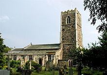
Burstwick's church is All Saints', which was designated a Grade I listed building in 1966 and is now recorded in the National Heritage List for England, maintained by Historic England. There is also a Methodist church.
Amenities
Burstwick contains a public house, the Hare and Hounds, a village shop and post office, and a fish and chip shop, all situated on the main street. Village businesses and services include a petrol station and car garage. An 18-hole golf course is 1 mile (1.6 km) away.
The local primary school is Burstwick Community Primary School.