
Population 189 (2001) Sovereign state United Kingdom Dialling code 01473 | OS grid reference TM0944 District Babergh | |
 | ||
Burstall is a village and civil parish in Suffolk, England. Located around 4 miles (6 km) west of Ipswich, it is part of Babergh district. The parish includes the hamlet of Burstallhill. Recorded in the Domesday Book as Burgestala / Burghestala.
Contents
Map of Burstall, Ipswich, UK
The south-western boundary of the parish is delineated by Belstead Brook, a tributary of the River Orwell. The A1071 between Ipswich and Hadleigh crosses Belstead Brook at Burstall Bridge.
Burstall Hall is ⅔ mile (1 km) northeast from the village.
Mill Farm is to the west and Hill Farm to the east.
The village hall built in 1910 in memory of John Cranfield. It is a Mock Tudor building with a recent lottery grant improvements. No alcohol is sold in the hall.
The Half Moon public house closed in 1968 and the Post office closed in 2006.
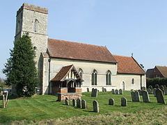
St Mary's Church
The parish church of St Mary has been a Grade I listed building since 22 February 1955. It is largely early 14th-century and 15th-century and was restored in 1866 and again, between 1870 and 1873, by Frederick Barnes of Ipswich.