
OS grid SO381830 Elevation 358 m | Topo map OS Landranger 137 Prominence 189 m Listing Marilyn | |
 | ||
Similar Heath Mynd, Brown Clee Hill, Caer Caradoc | ||
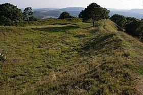
Burrow is a hill in Shropshire with an Iron Age hill fort at the summit known as Burrow Camp. The nearest villages are Hopesay and Aston-on-Clun. It includes a large number of hut platforms, and two natural springs.
Map of Burrow, Craven Arms, UK
At 15:45 on 13 September 1943 a Vickers Wellington crashed on the hill. The flight was part of a cross-country and practice bombing exercise from RAF Chipping Warden, Oxfordshire. The crew encountered a severe thunderstorn above south Shropshire and was seen to be struck by lighting while flying over Lydbury North causing the plane to catch fire and lose height before disintegrating on the hilltop killing all eight crew members.
References
Burrow (Shropshire) Wikipedia(Text) CC BY-SA