
Type Cataract Total width 250 feet (76 m) Elevation 1 m Number of drops 1 | Total height 114 feet (35 m) Watercourse Burney Creek Height 39 m | |
 | ||
Averageflow rate 195.0 cu ft/s (5.52 m/s) Similar Mossbrae Falls, Cascade Range, Mount Shasta, Lassen Peak, Alamere Falls | ||
Burney falls northern california attractions
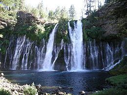
Burney Falls is a waterfall on Burney Creek, in McArthur-Burney Falls Memorial State Park, Shasta County, California.
Contents
- Burney falls northern california attractions
- Map of Burney Falls California USA
- Visit mcarthur burney falls memorial state park california united states best waterfall
- References
Map of Burney Falls, California, USA
The water comes from underground springs above and at the falls, which are 129 feet high, and provides an almost constant flow rate of 379 million litres per day, even during the dry summer months.
The falls are an example of river drainage regulated by stratigraphically-controlled springs, and also of a waterfall formed by undercutting of horizontal strata.
The falls were called "the Eighth Wonder of the World" by President Theodore Roosevelt, and were declared a National Natural Landmark in December 1954.
Visit mcarthur burney falls memorial state park california united states best waterfall
References
Burney Falls Wikipedia(Text) CC BY-SA