
- elevation 2,555 ft (779 m) Length 40 km | - elevation 4,155 ft (1,266 m) - average 282 cu ft/s (8 m/s) Discharge 7.985 m³/s Country United States of America | |
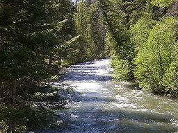 | ||
The Bumping River is a tributary of the Naches River, in Washington in the United States. It flows down the east side of the Cascade Range, through Wenatchee National Forest and the William O. Douglas Wilderness. From its source at Fish Lake near Crag Mountain, it flows northeast to Bumping Lake, a natural lake enlarged and regulated by Bumping Lake Dam. Below the dam, the Bumping River continues flowing northeast. It is joined by the American River, its main tributary, a few miles above its mouth where it joins the Little Naches River to form the Naches River.
Map of Bumping River, Washington, USA
Bumping River is part of the Columbia River basin, being a tributary of the Naches River, which is tributary to the Yakima River, which is tributary to the Columbia River.
Stockmen said that the river's name was given because during a freshet heavy boulders were carried down the river creating a rumbling vibration as the rocks kept bumping together. Variant names listed by the USGS for the Bumping River include Tancum River and Tanum River.