
- elevation 434 m (1,424 ft) - elevation 206 m (676 ft) | - location west of Myrtleford | |
 | ||
- left Catherine River (Victoria), Brandy Creek, Four Mile Creek (Victoria), Dandongadale River, Cropper Creek, Long Corner Creek - right Camp Creek (Victoria), Yarrarabula Creek, Sandy Creek (Buffalo River, Victoria) - location | ||
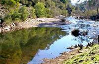
The Buffalo River, a perennial river of the North-East Murray catchment of the Murray-Darling basin, is located in the alpine region of Victoria, Australia. It flows from the eastern slopes of the Buffalo Range in the Australian Alps, joining with the Ovens River west of Myrtleford.
Contents
Map of Buffalo River, Victoria, Australia
Location and features
Formed by the east and west branches of the river, the headwaters of the Buffalo River rise in the Barry Mountains below Mount Selwyn and The Razor at an elevation exceeding 1,300 metres (4,300 ft) above sea level. The east and west branches of the river reach their confluence within the Mount Buffalo National Park, where the watercourse becomes the Buffalo River. The river flows generally north, much of its course through the remote national park, joined by nine tributaries including the Catherine River and the Dandongadale River, before reaching its confluence with the Ovens River west of the town of Myrtleford and adjacent to the Great Alpine Road. The river descends 228 metres (748 ft) over its 65-kilometre (40 mi) course.
The river is impounded by the Buffalo Dam that creates the 24,000-megalitre (5.3×10^9 imp gal; 6.3×10^9 US gal) reservoir, called Lake Buffalo, that was completed in 1965 and supplies potable water to Myrtleford and irrigation of the Goulburn Valley.