
Country Thailand Capital Bueng Kan | Area 4,305 km2 Population 418,566 | |
 | ||
Map of Bueng Kan Province
Bueng Kan (Thai: บึงกาฬ, [bɯ̄ŋ kāːn]), also spelled Bung Kan, is the 76th province (changwat) of Thailand, established by the Act Establishing Changwat Bueng Kan, BE 2554 (2011) on 23 March 2011. The province, consisting of the districts (amphoe) partitioned off Nong Khai Province, is in the northeastern region of the country, called Isan (Thai: อีสาน). It is named after its central district, Mueang Bueng Kan.
Contents
- Map of Bueng Kan Province
- Bueng kan province and its stairways to heaven wat phu tok
- Geography
- History
- Provincial seal
- Climate
- Administrative divisions
- References
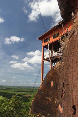
Bueng kan province and its stairways to heaven wat phu tok
Geography
The province is in the northeastern corner of Thailand. It borders, from the south clockwise, Nakhon Phanom, Sakon Nakhon, and Nong Khai Province. To the north and east it borders Bolikhamsai Province of Laos, with the Mekong River forming the boundary.
In Bung Khla district is the Phu Wua Wildlife Sanctuary, protecting forest-covered hills close to the Mekong River.
History
In 1994, Sumet Phromphanhao, a member of the House of Representatives from Nong Khai Province, proposed that the province of Bueng Kan be established by consolidating Amphoe Bueng Kan, Amphoe Seka, Amphoe So Phisai, Amphoe Bung Khla, Amphoe Bueng Khong Long, Amphoe Pak Khat, Amphoe Phon Charoen, and Amphoe Si Wilai of Nong Khai Province as a new province. The new province, if created, would be 4,305 km2, with a population of about 390,000 inhabitants. At that time, the Ministry of Interior replied that creating a new province would load a heavy burden to the state budget and was contrary to the resolution of the Council of Ministers.
The proposal to create Bueng Kan Province was tabled for about 20 years, until 2010 when the Ministry of Interior renewed the project and made a proposal to the Council of Ministers to have a "Bill Establishing Changwat Bueng Kan, BE..." (Thai: ร่างพระราชบัญญัติจัดตั้งจังหวัดบึงกาฬ พ.ศ....) considered. In a poll at the time, 98.83% of the inhabitants of Nong Khai Province supported the proposal. On 3 August 2010, the Council of Ministers resolved to present the bill to the National Assembly, citing that the proposal met its criteria for approval.
On 7 February 2011, the National Assembly approved the bill. Prime Minister Abhisit Vejjajiva presented it to King Bhumibol Adulyadej for royal assent. Bhumibol Adulyadej signed the bill on 11 March 2011, enacting it as the "Act Establishing Changwat Bueng Kan, BE 2554 (2011)" (Thai: พระราชบัญญัติตั้งจังหวัดบึงกาฬ พ.ศ. 2554). The act was published in the Government Gazette on 22 March 2011 and came into force the next day.
Provincial seal
The provincial seal of Bueng Kan, Thailand's 77th and newest province, has a depiction of Phu Thok, a mountain in Si Wilai District, an Isan language name which means "Lonely Mountain".
The provincial flower and tree is Bauhinia sirindhorniae K. and S.S. Larsen.
Climate
Bueng Kan’s climate consists wet season and dry season (between December and January). The temperature decreases during November and will be lowest in December and January. The temperature quickly increases in March, and will be highest in April.
Administrative divisions
The province is divided into eight districts (amphoe). The districts are further subdivided into 53 subdistricts (tambon) and 615 villages (muban).