
Airport type Public Elevation AMSL 31 ft / 9 m 3,200 975 Elevation 9.45 m | 11/29 3,200 Code BKC Phone +1 907-451-5250 | |
 | ||
Owner State of Alaska DOT&PF - Northern Region Address Buckland, AK, United States | ||
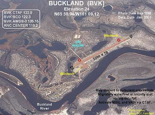
Buckland Airport (IATA: BKC, ICAO: PABL, FAA LID: BVK, formerly 7K5) is a state-owned public-use airport located one nautical mile (1.85 km) southwest of the central business district of Buckland, a city in the Northwest Arctic Borough of the U.S. state of Alaska. The airport is situated on the Buckland River.
Although most U.S. airports use the same three-letter location identifier for the FAA and IATA, this airport is assigned BVK by the FAA and BKC by the IATA (which assigned BVK to Huacaraje, Bolivia). The airport's ICAO identifier is PABL.
Facilities and aircraft
Buckland Airport covers an area of 184 acres (74 ha) at an elevation of 31 feet (9 m) above mean sea level. It has one runway designated 11/29 with a gravel surface measuring 3,200 by 75 feet (975 x 23 m).