
Principal cities College StationBryan Urban area 184.9 km² | State Texas Time zone CST (UTC-6) | |
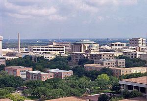 | ||
Bryan–College Station is a metropolitan area centering on the twin cities of Bryan and College Station in the Brazos Valley region of Texas. The 2010 census placed the population of the three county metropolitan area at 255,519.
Contents
- Map of College Station Bryan TX TX USA
- Counties
- Places with more than 75000 people
- Places with 1000 to 7000 people
- Places with fewer than 1000 people
- Unincorporated places
- Metropolitian Statistical Area
- Demographics
- References
Map of College Station-Bryan, TX, TX, USA
The area's economic and social life is centered on the main campus of Texas A&M University in College Station; thus, the area is popularly known as "Aggieland" in reference to the Aggies nickname for the university's sports teams and students.
Counties
Places with more than 75,000 people
Places with 1,000 to 7,000 people
Places with fewer than 1,000 people
Unincorporated places
Metropolitian Statistical Area
The College Station–Bryan, TX Metropolitan Statistical Area (MSA) encompasses three counties: Brazos, Burleson, and Robertson. The College Station–Bryan MSA encompasses 2,123 sq mi (5,524 km2) of area, of which 2,100 sq mi (5,439 km2) is land and 33.5 sq mi (87 km2) is water.
Demographics
As of the census of 2000, there were 184,885 people, 67,744 households, and 39,346 families residing within the MSA. The racial makeup of the MSA was 63.71% White, 30.27% African American, 0.38% Native American, 3.33% Asian, 0.06% Pacific Islander, 8.30% from other races, and 1.95% from two or more races. Hispanic or Latino of any race were 17.32% of the population.
The median income for a household in the MSA was $30,339 and the median income for a family was $40,442. Males had a median income of $30,818 versus $21,951 for females. The per capita income for the MSA was $15,847.