
Norse name Bruray Area rank 189= Highest elevation 53 m | OS grid reference HU689720 Population 24 Area 55 ha Lieutenancy area Shetland | |
 | ||
Bruray is one of the three Out Skerries islands of Shetland, and contains Scotland's most easterly settlement.
Contents
Map of Bruray, United Kingdom
It is separated from Housay by North Mouth and South Mouth.
Infrastructure
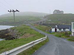
The Skerries Bridge was built in 1957 to provide a fixed link from Bruray to the neighbouring and larger island of Housay
Bruray is home to Scotland's smallest school.
The island occasionally suffers from water shortages. There is little peat on the Out Skerries, so the residents have been granted rights to cut in on Whalsay.
A ferry connects the Out Skerries with Vidlin and Lerwick on the Shetland Mainland, as well as flights from Tingwall by Loganair.
History
At the autumn 2010, the islands of Housay and Bruray were on sale for £250,000. "The main islands are held under crofting tenure. The crofting community have been offered the opportunity to register their interest in acquiring the property but have formally declined from doing so."