
 | ||
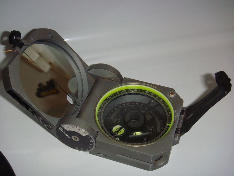
A Brunton compass, properly known as the Brunton Pocket Transit, is a type of precision compass made by Brunton, Inc. of Riverton, Wyoming. The instrument was patented in 1894 by a Canadian-born Colorado geologist named David W. Brunton. Unlike most modern compasses, the Brunton Pocket Transit utilizes magnetic induction damping rather than fluid to damp needle oscillation. Although Brunton Inc. makes many other types of magnetic compasses, the Brunton Pocket Transit is a specialized instrument used widely by those needing to make accurate degree and angle measurements in the field. These people are primarily geologists, but archaeologists, environmental engineers, and surveyors also make use of the Brunton's capabilities. The United States Army has adopted the Pocket Transit as the M2 Compass for use by crew-served artillery.
Contents
Overview
The Pocket Transit may be adjusted for declination angle according to one's location on the Earth. It is used to get directional degree measurements (azimuth) through use of the Earth's magnetic field. Holding the compass at waist-height, the user looks down into the mirror and lines up the target, needle, and guide line that is on the mirror. Once all three are lined up and the compass is level, the reading for that azimuth can be made. Arguably the most frequent use for the Brunton in the field is the calculation of the strike and dip of geological features (faults, contacts, foliation, sedimentary strata, etc.). If next to the feature, the strike is measured by leveling (with the bull's eye level) the compass along the plane being measured. Dip is taken by laying the side of the compass perpendicular to the strike measurement and rotating horizontal level until the bubble is stable and the reading has been made. If properly used and if field conditions allow, additional features of the compass allow users to measure such geological attributes from a distance.
As with most traditional compasses, directional measurements are made in reference to the Earth's magnetic field and will thus run into difficulties if in a region of locally abnormal magnetism. For example, if the user is near an outcrop that contains magnetite or some other iron-bearing material, compass readings can be affected anywhere from several inches from the outcrop to tens of yards away (depending on the strength of the magnetic field). Since they are measured only using a rotating level, dip measurements are unaffected by magnetic fields.
Other compasses
There are numerous other compasses used by geologists: The Breithaupt compass is another example. It is commonly used by structural geologists because it readily allows accurate measurement of the orientation of planes (foliations) and of lines on those planes (lineations). With the advent of portable electronic devices a new generation of compasses has emerged, some again of specific interest to geologists. Unlike analogue compasses, a digital compass relies on an accelerometer and a teslameter, and may provide much information as to the reliability of a measurement (e.g. by repeating the same measurement and performing statistical analysis).
Smartphone apps
Programmers of today's smartphones have responded with different geological compass apps. However, caution must be exercised: because the Earth's magnetic field fluctuates rapidly, smartphone 3-axis magnetometers can potentially measure noise. Furthermore, all smartphones create strong magnetic fields that must be corrected for. At present, all geological compass apps should be tested against traditional magnetic compass measurements.
Uses
- Taking bearing with the compass
- Magnetic declination setting
- Measuring vertical angles with clinometer
- Defining points of the same elevation
- Measuring strike and dip.