
Mouth Lake Superior | ||
 | ||
The Brule River is a river of the U.S. state of Minnesota. The Brule River originates at Vista Lake in the Boundary Waters Canoe Area Wilderness and flows 40.4 miles (65.0 km) east and southeast, terminating at Lake Superior approximately 14 mi (23 km) northeast of Grand Marais, Minnesota, within the boundaries of Judge C. R. Magney State Park. A major tributary is the South Brule River, which rises at the east end of Brule Lake in the Boundary Waters Canoe Area Wilderness.
Map of Brule River, East Cook, MN, USA
Brule River is a name derived from the French meaning "burnt".
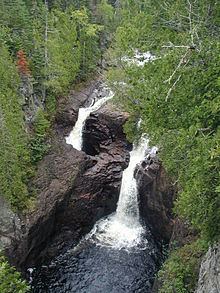
Half of the river disappears into a pothole known as "the Devil's Kettle" in Judge C. R. Magney State Park.
References
Brule River (Minnesota) Wikipedia(Text) CC BY-SA