
Easiest route Hiking | Elevation 1,590 m | |
 | ||
Similar Brandberg Mountain, Verbrannter Berg, Gamsberg (Namibia), Vingerklip, Grootberg | ||
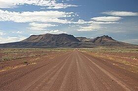
Brukkaros Mountain is an extinct volcano in ǁKaras Region, Namibia. Measuring 1,590 metres at its peak, Brukkaros is located about 15 kilometres northeast of the primarily Nama town of Berseba. It is over 600 metres taller than the surrounding area.
Contents
Map of Brukkaros Mountain, Namibia
The mountain is a large extinct volcano, in the form of a ring mountain (a so-called tuff ring) with a diameter of about 4 km and has been formed by an explosion when rising magma met groundwater and superheated it. It is formed of an indistinctly bedded red-brown microbreccia, composed of finely fragmented rocks of the Nama System that were blown out of a volcanic vent about 80 million years ago. The breccia layers slope inwards (unlike the slope around a volcanic crater), and removal of the softer upper layers by erosion has created the central hollow. The hollow is drained by a stream which runs southwards through the ring mountain in a narrow valley. The route into the interior of the mountain is along this valley. At its head is a dry waterfall, over which the stream plunges down some 45 m after rain, and the river bed directly below the fall is the principal source of water.
History
From 1926-1931, the National Geographic Society, in cooperation with the Smithsonian Institution, ran the Brukkaros Solar Observatory on the mountain to measure daily solar radiation.