
NRHP Reference # 97000952 Year built 1895 | Area 8 ha Added to NRHP 5 September 1997 | |
 | ||
Architectural style Late 19th And 20th Century Revivals, Queen Anne, Late Victorian | ||
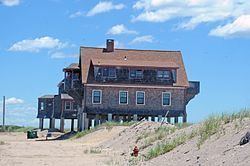
Browning's Beach Historic District is a historic district west of the junction between Card Pond and Matunuck Beach Roads in South Kingstown, Rhode Island. It encompasses a cluster of four beach houses located on a barrier beach facing Long Island Sound south of Cards Pond, and accessed via a private gravel drive extending from Cards Pond Road. The four houses, along with several outbuildings, were built in the early years of the 20th century, and are architecturally diverse expressions of Queen Anne, Shingle, and Colonial Revival elements. Typical architectural elements include shingle siding, recessed porches, and chalet-style roofs.
The district was listed on the National Register of Historic Places in 1997.
References
Browning's Beach Historic District Wikipedia(Text) CC BY-SA