
Country United States Elevation 131 ft (40 m) Zip code 04617 Local time Saturday 12:30 PM | State Maine Incorporated 1817 Time zone Eastern (EST) (UTC-5) Population 934 (2010) | |
 | ||
Weather -12°C, Wind NW at 27 km/h, 31% Humidity Area 132.4 km² (80.63 km² Land / 51.77 km² Water) | ||
Brooksville is a town on Penobscot Bay in Hancock County, Maine, United States. As of the 2010 census, the town population was 934. It contains the villages of North Brooksville, South Brooksville (on Buck's Harbor), West Brooksville, Brooksville Corner, and Harborside (on Cape Rosier).
Contents
- Map of Brooksville ME USA
- History
- Geography
- 2010 census
- 2000 census
- Points of interest
- National historic sites
- Notable people
- References
Map of Brooksville, ME, USA
History
It was first settled by John Wasson, Samuel Wasson and David Hawes, soldiers in the Revolutionary War. Incorporated on June 13, 1817, the town was formed from parts of Castine, Penobscot and Sedgwick. It was named Brooksville after Governor John Brooks of Massachusetts, which then governed Maine.
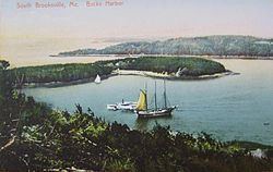
The surface of the town abounds with granite, and several quarries were established. The soil is a clay loam, which yielded wheat and potatoes. Buck's Harbor, safe and deep, is one of the best coves in the region for small boats, and many residents became involved in the coasting trade and fisheries. By 1880, when the population was 1,419, Brooksville had a porgy oil factory, two sawmills, a shingle mill, a planing mill, two gristmills, a wool carding mill, and a cloth and yarn factory. Shipping was an industry, with ship repairs done at the foot of Wasson's Wharf Road with a pier to the channel in the Bagaduce. There was a brickyard, blacksmith's shop, rope walk and small store for provisions. As late as 1912, there were 18 schooners at the wharf under repair. A small packet, the Goldenrod, ferried passengers from Brooksville to Castine and there was a pier to the south where the Belfast boat berthed. The Wasson and Tapley families, related by marriage, had numerous ship's captains, the most notable being the six Tapley sons of Captain Robert Tapley, who all followed the sea after their father.
Brooksville's Cape Rosier is named after James Rosier, an early explorer of the Penobscot River.
Geography
According to the United States Census Bureau, the town has a total area of 51.12 square miles (132.40 km2), of which 31.13 square miles (80.63 km2) is land and 19.99 square miles (51.77 km2) is water. Brooksville is bounded on the west by Penobscot Bay, on the north and east by the Bagaduce River, a tidal estuary, and on the south by Eggemoggin Reach. It is nearly an island, with just two slim land bridges to the rest of the mainland. It has 53.75 miles (86.50 km) of shoreline.
Brooksville is crossed by state routes 175 and 176.
2010 census
As of the census of 2010, there were 934 people, 437 households, and 292 families residing in the town. The population density was 30.0 inhabitants per square mile (11.6/km2). There were 934 housing units at an average density of 30.0 per square mile (11.6/km2). The racial makeup of the town was 95.6% White, 0.2% Native American, 1.9% Asian, 0.5% from other races, and 1.7% from two or more races. Hispanic or Latino of any race were 1.1% of the population.
There were 437 households of which 20.4% had children under the age of 18 living with them, 57.0% were married couples living together, 6.9% had a female householder with no husband present, 3.0% had a male householder with no wife present, and 33.2% were non-families. 26.1% of all households were made up of individuals and 11.2% had someone living alone who was 65 years of age or older. The average household size was 2.14 and the average family size was 2.52.
The median age in the town was 53 years. 15.3% of residents were under the age of 18; 5.8% were between the ages of 18 and 24; 18% were from 25 to 44; 35.7% were from 45 to 64; and 25.2% were 65 years of age or older. The gender makeup of the town was 48.0% male and 52.0% female.
2000 census
As of the census of 2000, there were 911 people, 412 households, and 278 families residing in the town. The population density was 29.3 people per square mile (11.3/km²). There were 791 housing units at an average density of 25.4 per square mile (9.8/km²). The racial makeup of the town was 98.68% White, 0.44% Asian, 0.22% Pacific Islander, and 0.66% from two or more races. Hispanic or Latino of any race were 0.33% of the population.
There were 412 households out of which 23.1% had children under the age of 18 living with them, 60.7% were married couples living together, 4.9% had a female householder with no husband present, and 32.5% were non-families. 26.2% of all households were made up of individuals and 11.7% had someone living alone who was 65 years of age or older. The average household size was 2.21 and the average family size was 2.65.
In the town, the population was spread out with 18.0% under the age of 18, 5.3% from 18 to 24, 21.3% from 25 to 44, 34.8% from 45 to 64, and 20.6% who were 65 years of age or older. The median age was 49 years. For every 100 females there were 100.2 males. For every 100 females age 18 and over, there were 95.5 males.
The median income for a household in the town was $36,458, and the median income for a family was $41,875. Males had a median income of $26,923 versus $24,750 for females. The per capita income for the town was $23,565. About 7.6% of families and 9.7% of the population were below the poverty line, including 13.5% of those under age 18 and 2.2% of those age 65 or over.