
OS grid reference TQ990259 Population 479 (2011) | Sovereign state United Kingdom Postcode district TN29 Local time Saturday 4:26 PM District Shepway | |
 | ||
Weather 9°C, Wind SW at 21 km/h, 76% Humidity | ||
Brookland is a village and civil parish in the Shepway district of Kent, England, about 5 miles (8 km) west of New Romney. According to the 2001 census the parish had a population of 453, increasing to 479 at the 2011 Census. It is located on the A259 road in Romney Marsh.
Map of Brookland, UK
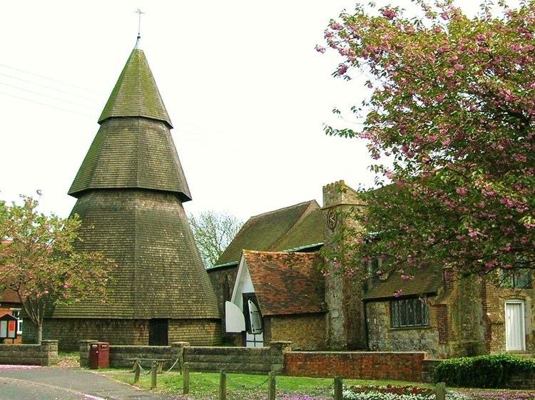
The parish Church of St Augustine has the unusual, if not unique, feature of an entirely wooden spire being separate from the body of the church. Popular myth is that the steeple looked down at a wedding service to see such a beautiful bride marrying such an unpleasant groom that it jumped off the church in shock. A more popular story is that one day a virgin presented herself to be married and the church spire fell off at the unusual occurrence. In fact, it is separate as the weight can not be supported by the marshy ground.
Inside the church there is a round lead font dating from the 12th century. Around its circumference are panels with reliefs showing the 12 Zodiac signs and the typical labours of each month.
In 1821 Brookland was the scene of the Battle of Brookland, between a band of smugglers known as the Aldington Gang, and Customs and Excise men; five were killed and many wounded.
Brookland is a pretty village but it suffers from the common problem of many rural English villages, of becoming a mere residential estate, despite being as far as 7 miles (11 km) from the nearest shopping centre (Rye). As late as 1970 there was a post office, 5 shops - including Coleman's, a butcher well known locally for his pork sausages - a tea room, a garage, blacksmith, abattoir, a vicar and 3 pubs. Only two of the pubs now remain, The Alliance having closed in the early 1980s and is now private house. Of the remaining pubs, the Royal Oak is situated in the village by the church, whilst the Woolpack Inn continues to operate 1 mile (1.6 km) south of the village. The nearest general stores are now at Appledore (5 miles (8 km)), Hamstreet (6 miles (10 km)) and New Romney (6 miles (10 km)).