
Country United States FIPS code 36-08213 Elevation 573 m Population 1,435 (2010) | State New York Time zone Eastern (EST) (UTC-5) GNIS feature ID 0978752 Local time Friday 8:49 AM | |
 | ||
Weather -13°C, Wind SW at 13 km/h, 76% Humidity Area 215 km² (201.8 km² Land / 13.21 km² Water) | ||
Brighton is a town in Franklin County, New York, United States. The population was 1,435 at the 2010 census. It was named after Brighton, England, by early surveyors in the region.
Contents
Map of Brighton, NY, USA
The town is in the southern part of the county and is inside the Adirondack Park. Paul Smith's College is in the community of Paul Smiths, a hamlet of Brighton.
History
The first settlers in this area arrived around 1815. The town of Brighton was set aside from the Duane in 1858. James M. Wardner was elected its first supervisor. Apollos "Paul" Smith arrived in 1859 and gradually built up a hotel in the community that bears his name. Having become an important Adirondack hotel, Paul Smith's College was established by his family. The college now uses the land where the hotel once stood along Lower St. Regis Lake. Also around that time James Wardner had a small hotel on Rainbow Lake.
Among the "second round" of settlers in the town of Brighton after its pioneers Follensby, S. Johnson, the Rice brothers, Amos and Levi; Oliver Keese and Thomas A. Tomlinson; James and Seth Wardner, were the Ricketsons, the Rands, the Dustins, Jute Q. King and his son, Philemon King. They were scattered along the highway from Keese Mill and McColloms to Paul Smiths to Easy Street to the Split Rock Road and to Rainbow Lake and Jones Pond.
The hamlet now called Gabriels originated back when only the Rands, the Ricketsons, the Dustins, and the Otises were settled on farms nearer to the Split Rock Road and Ricketson Brook in the southern part of the town along the boundary with the town of Harrietstown than where Gabriels is currently situated. It wasn't until the Adirondack & St. Lawrence Railway came in 1892 that Gabriels expanded northward, with many settling near the railroad station. Following the arrival of the railroad, the Sisters of Mercy came to the town and established a tuberculosis sanitorium, and Muncil's sawmill was founded. Paul Smith's Hotel immediately started a stage line to the railroad station. The Gabriels Sanatorium, opened in 1897, later became Camp Gabriels, a minimum-security state prison.
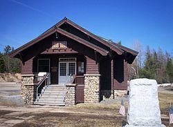
The Brighton Town Hall was designed and built by Benjamin A. Muncil in 1914. Muncil was a talented local builder who also designed and built Marjorie Merriweather Post's Camp Topridge, and White Pine Camp, which was used as a summer White House of US President Calvin Coolidge. It was listed on the National Register of Historic Places in 2003.
Geography
Brighton is located south of the center of Franklin County within the limits of the Adirondack Forest Preserve. According to the United States Census Bureau, the town has a total area of 83.0 square miles (215.0 km2), of which 77.9 square miles (201.7 km2) is land and 5.1 square miles (13.2 km2), or 6.15%, is water. The majority of the town consists of woodlands, lakes, streams and ponds (both publicly and privately owned), with a few areas of developed hamlets and farmland (privately owned). Major water bodies include Upper and Lower St. Regis Lake in the southwest corner of town.
New York State Route 30 is a north-south highway in the town and intersects New York State Route 86 at Paul Smiths. NY 30 leads north 32 miles (51 km) to Malone, the Franklin County seat, and southwest 26 miles (42 km) to Tupper Lake. NY 86 leads southeast 12 miles (19 km) to Saranac Lake.
Demographics
As of the census of 2000, there were 1,682 people, 319 households, and 203 families residing in the town. The population density was 21.6 people per square mile (8.3/km²). There were 591 housing units at an average density of 7.6 per square mile (2.9/km²). The racial makeup of the town was 79.37% White, 18.55% African American, 0.65% Native American, 1.19% Asian, and 0.24% from two or more races. Hispanic or Latino of any race were 0.48% of the population.
There were 319 households out of which 34.5% had children under the age of 18 living with them, 53.9% were married couples living together, 5.0% had a female householder with no husband present, and 36.1% were non-families. 29.2% of all households were made up of individuals and 9.1% had someone living alone who was 65 years of age or older. The average household size was 2.46 and the average family size was 3.04.
In the town, the population was spread out with 11.7% under the age of 18, 37.5% from 18 to 24, 29.8% from 25 to 44, 15.5% from 45 to 64, and 5.4% who were 65 years of age or older. The median age was 26 years. For every 100 females there were 215.0 males. For every 100 females age 18 and over, there were 246.2 males.
The median income for a household in the town was $42,679, and the median income for a family was $48,250. Males had a median income of $35,952 versus $26,250 for females. The per capita income for the town was $11,995. About 3.0% of families and 6.2% of the population were below the poverty line, including 5.3% of those under age 18 and 8.7% of those age 65 or over.