
Country United States FIPS code 30-09475 Elevation 1,117 m Zip code 59014 Local time Friday 4:10 AM | Time zone Mountain (MST) (UTC-7) GNIS feature ID 0802058 Area 207 ha Population 728 (2013) Area code 406 | |
 | ||
Weather 6°C, Wind S at 34 km/h, 38% Humidity | ||
Bridger is a town in Carbon County, Montana, United States. It is part of the Billings, Montana Metropolitan Statistical Area. The population was 708 at the 2010 census.
Contents
Map of Bridger, MT 59014, USA
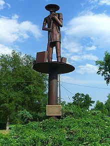
The town of Bridger was named for the scout Jim Bridger. Residents originally wanted to name the town after George Town, one of the original settlers, but Town encouraged residents to name the newly founded town after his old friend Jim Bridger. The Bridger Trail passes to the southeast of the town of Bridger.
Geography
Bridger is located at 45°17′40″N 108°54′59″W (45.294337, -108.916421).
According to the United States Census Bureau, the town has a total area of 0.80 square miles (2.07 km2), all of it land. The Clark's Fork of the Yellowstone River runs through the eastern part of the town.
History
The Bridger Post Office was officially established on October 29, 1898 with Jno. M. Babcock as the town's first postmaster.
In December 2014, construction began on a large wind farm, Mud Springs Wind Ranch, with 120 wind turbines, at a site 12 miles southeast of Bridger.
Climate
According to the Köppen Climate Classification system, Bridger has a semi-arid climate, abbreviated "BSk" on climate maps.
2010 census
As of the census of 2010, there were 708 people, 315 households, and 195 families residing in the town. The population density was 885.0 inhabitants per square mile (341.7/km2). There were 347 housing units at an average density of 433.8 per square mile (167.5/km2). The racial makeup of the town was 95.5% White, 0.1% African American, 2.7% Native American, 0.3% Asian, 0.3% from other races, and 1.1% from two or more races. Hispanic or Latino of any race were 1.8% of the population.
There were 315 households of which 24.8% had children under the age of 18 living with them, 46.3% were married couples living together, 9.5% had a female householder with no husband present, 6.0% had a male householder with no wife present, and 38.1% were non-families. 31.1% of all households were made up of individuals and 14.6% had someone living alone who was 65 years of age or older. The average household size was 2.25 and the average family size was 2.84.
The median age in the town was 45.7 years. 22.2% of residents were under the age of 18; 5.4% were between the ages of 18 and 24; 21.6% were from 25 to 44; 29.9% were from 45 to 64; and 20.8% were 65 years of age or older. The gender makeup of the town was 48.2% male and 51.8% female.
2000 census
As of the census of 2000, there were 745 people, 313 households, and 200 families residing in the town. The population density was 1,175.2 people per square mile (456.6/km²). There were 345 housing units at an average density of 544.2 per square mile (211.4/km²). The racial makeup of the town was 98.12% White, 0.40% Native American, 0.13% from other races, and 1.34% from two or more races. Hispanic or Latino of any race were 3.62% of the population.
There were 313 households out of which 28.4% had children under the age of 18 living with them, 49.2% were married couples living together, 9.9% had a female householder with no husband present, and 36.1% were non-families. 31.9% of all households were made up of individuals and 15.0% had someone living alone who was 65 years of age or older. The average household size was 2.36 and the average family size was 2.94.
In the town, the population was spread out with 27.5% under the age of 18, 7.9% from 18 to 24, 24.0% from 25 to 44, 23.2% from 45 to 64, and 17.3% who were 65 years of age or older. The median age was 40 years. For every 100 females there were 97.6 males. For every 100 females age 18 and over, there were 92.2 males.
The median income for a household in the town was $26,103, and the median income for a family was $32,981. Males had a median income of $24,063 versus $18,929 for females. The per capita income for the town was $17,060. About 10.7% of families and 16.2% of the population were below the poverty line, including 21.8% of those under age 18 and 10.4% of those age 65 or over.