
Country United States FIPS code 31-06295 Elevation 1,117 m Zip code 69336 Local time Friday 4:06 AM | Time zone Mountain (MST) (UTC-7) GNIS feature ID 0827643 Area 2.98 km² Population 1,522 (2013) Area code 308 | |
 | ||
Weather -4°C, Wind S at 6 km/h, 72% Humidity | ||
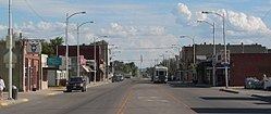
Bridgeport is a city in Morrill County, Nebraska, United States. The population was 1,545 at the 2010 census. It is the county seat of Morrill County.
Contents
Map of Bridgeport, NE 69336, USA
History
Bridgeport had its start in the year 1899 by the building of the Chicago, Burlington and Quincy Railroad through that territory. The town that sprang up took its name from a bridge over the North Platte River. Bridgeport was incorporated as a village in 1901.
Geography
Bridgeport is located at 41°40′4″N 103°5′56″W (41.667643, -103.098787).
According to the United States Census Bureau, the city has a total area of 1.15 square miles (2.98 km2), all of it land.
2010 census
As of the census of 2010, there were 1,545 people, 644 households, and 407 families residing in the city. The population density was 1,343.5 inhabitants per square mile (518.7/km2). There were 728 housing units at an average density of 633.0 per square mile (244.4/km2). The racial makeup of the city was 87.1% White, 0.5% African American, 1.9% Native American, 0.8% Asian, 8.1% from other races, and 1.6% from two or more races. Hispanic or Latino of any race were 19.2% of the population.
There were 644 households of which 30.0% had children under the age of 18 living with them, 50.0% were married couples living together, 9.6% had a female householder with no husband present, 3.6% had a male householder with no wife present, and 36.8% were non-families. 33.7% of all households were made up of individuals and 19% had someone living alone who was 65 years of age or older. The average household size was 2.34 and the average family size was 3.01.
The median age in the city was 40.3 years. 25.7% of residents were under the age of 18; 8% were between the ages of 18 and 24; 21.8% were from 25 to 44; 23.5% were from 45 to 64; and 21.1% were 65 years of age or older. The gender makeup of the city was 47.1% male and 52.9% female.
2000 census
As of the census of 2000, there were 1,594 people, 654 households, and 419 families residing in the city. The population density was 1,671.1 people per square mile (647.8/km²). There were 723 housing units at an average density of 758.0 per square mile (293.8/km²). The racial makeup of the city was 90.72% White, 0.13% African American, 1.57% Native American, 0.31% Asian, 4.96% from other races, and 2.32% from two or more races. Hispanic or Latino of any race were 14.81% of the population.
There were 654 households out of which 30.6% had children under the age of 18 living with them, 53.2% were married couples living together, 7.5% had a female householder with no husband present, and 35.8% were non-families. 32.9% of all households were made up of individuals and 15.9% had someone living alone who was 65 years of age or older. The average household size was 2.38 and the average family size was 3.03.
In the city, the population was spread out with 26.1% under the age of 18, 7.3% from 18 to 24, 25.2% from 25 to 44, 22.5% from 45 to 64, and 18.9% who were 65 years of age or older. The median age was 39 years. For every 100 females there were 90.4 males. For every 100 females age 18 and over, there were 88.8 males.
As of 2000 the median income for a household in the city was $29,527, and the median income for a family was $37,813. Males had a median income of $30,037 versus $18,500 for females. The per capita income for the city was $14,320. About 7.7% of families and 12.0% of the population were below the poverty line, including 15.6% of those under age 18 and 9.4% of those age 65 or over.
Education
The Bridgeport Public Schools school district has one elementary school and one junior/senior high school, both located in Bridgeport.