
Location 4.7 km (2.9 mi) | ||
 | ||
Progression | ||
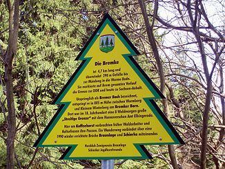
The Bremke is a 4.7-kilometre (2.9 mi) long headstream of the Bode River in Saxony-Anhalt and Lower Saxony, Germany.
Map of Bremke, Germany
It rises at an elevation of 805 metres (2,641 ft) in the Harz Mountains between the Lower Saxon mountain of Wurmberg near Braunlage and the Kleiner Winterberg near Schierke in Saxony-Anhalt. For its entire length the stream forms the boundary between the two German federal states and until 1990 between East and West Germany. Even today the old East German convoy road has survived not far from the eastern bank of the stream.
References
Bremke (river) Wikipedia(Text) CC BY-SA