
Elevation 3,389 m Prominence 462 m | First ascent 20 June 1878 | |
 | ||
Similar Aiguille de Chambeyron, Tête de la Fréma, Tête de Sautron, Buc de Nubiera, Pics de la Font Sancte | ||
Brec de chambeyron couloir nord bonacossa
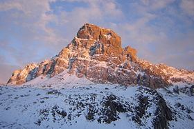
Brec de Chambeyron (3,389) is a mountain of the Cottian Alps on the border between France and Italy. It is the second highest summit of the Chambeyron Massif, after Aiguille de Chambeyron and its sharp, rocky peak dominates the Upper Ubaye Valley. The word "Brec" or "Bric" in French is used for a mountain resembling a rocky tooth. It was first climbed in 1878 by Paul Agnel and Joseph Risoul.
Contents
- Brec de chambeyron couloir nord bonacossa
- Map of Brec de Chambeyron 04530 Saint Paul sur Ubaye France
- Brec de chambeyron 3389 m valle maira
- References
Map of Brec de Chambeyron, 04530 Saint-Paul-sur-Ubaye, France
Brec de chambeyron 3389 m valle maira
References
Brec de Chambeyron Wikipedia(Text) CC BY-SA