
Topo map OS Landranger 196 | OS grid SZ595869 Elevation 123 m | |
 | ||
Similar Culver Down, Brighstone Down, Stenbury Down, St Boniface Down, Tennyson Down | ||
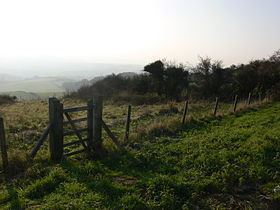
Brading Down is a chalk down southwest of Brading, Isle of Wight. It is a prominent hill which overlooks Sandown Bay, with spectacular views across the bay towards Shanklin, and Culver Down. It is a Local Nature Reserve.
Map of Brading Down, Brading, Sandown, UK
Parts of the down are private, including an area used as a covered reservoir, and some for agriculture. But much of the down, some 35 hectares (86 acres), is open to the public and is owned by the Isle of Wight Council. The main area of Brading Down is fenced and grazed but access on foot and for horse riders is available from the many pathways entering the area, and the car parks bordering the main Newport to Brading Road.
The thin chalk soils to the east of the site support a typical downland plant community with pyramidal orchids being a particular feature in the summer. In recent years a programme of scrub clearance has been undertaken. The area is good for butterflies including common blue, chalkhill blue, small, large and dingy skippers, marbled white, gatekeeper, and meadow brown.
In addition to the wildlife interest of chalk downland, the ancient field system on Brading Down is a Scheduled Monument. The finest surviving ancient field system on the Island is to be found on the down. This is likely to be of late Iron Age or Roman date and highlights the last time the fields were ploughed. The views over Brading Roman Villa and Sandown Levels reinforce the historical significance of the area. Further down the slopes, first world war practice trenches and former chalk pits show evidence of more recent archaeological interest.