
Country United States Type of dam earthfill Length 2,850 ft (870 m) Opened 1953 Create Lake Cachuma | Opening date 1953 Height 85 m Catchment area 1,080 km² Construction began 1950 | |
 | ||
Owner United States Bureau of Reclamation Similar Gibraltar Dam, Casitas Dam, Twitchell Reservoir, San Marcos Pass, Sly Park Dam | ||
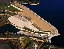
Bradbury Dam is an earthen dam across the Santa Ynez River in central Santa Barbara County, California. The dam forms Lake Cachuma, which provides the majority of water supplies within the county.
Map of Bradbury Dam, Santa Barbara, CA 93105, USA
Although the Santa Ynez can reach massive flows in the winter, it usually dries up for several months of the year in the summer. A large storage facility to catch winter floodwaters for use in the summer and autumn was desperately needed by the growing population of the region, especially that of south coast cities like Santa Barbara and Carpinteria. Even before Bradbury Dam was considered, the Gibraltar Dam was built upstream to divert water through a tunnel to the city of Santa Barbara. However, that dam was plagued by siltation and was unable to fully serve the water requirements of the city.
Construction on Bradbury Dam started in 1950 as part of a U.S. Bureau of Reclamation scheme called the Cachuma Project, intended to provide long-term water storage and delivery to Santa Barbara and other cities throughout the region as well as provide water for irrigation. Originally named the Cachuma Dam, it was completed in 1953; the name was later changed to honor a local water supply proponent.