
- elevation 508 m (1,667 ft) - elevation 205 m (673 ft) Province Ontario | - location Essa, Simcoe County Mouth Nottawasaga River | |
 | ||
- location Melancthon, Dufferin County | ||
The Boyne River is a river in Simcoe County and Dufferin County in Central Ontario, Canada. It is part of the Great Lakes Basin, and is a left tributary of the Nottawasaga River. The rivers falls within the jurisdiction of the Nottawasaga Valley Conservation Authority.
Contents
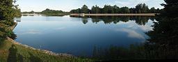
CourseEdit
The river begins at an unnamed pond in Melancthon, Dufferin County, that lies between the Toronto, Grey and Bruce Railway line and Ontario Highway 10. It heads southeast past the town of Shelburne, then heads east northeast roughly parallel to Ontario Highway 89 for the remainder of its course. It enters Mulmur, passes through Boyne Valley Provincial Park, and enters Adjala–Tosorontio in Simcoe County. The river goes through Earl Rowe Provincial Park, briefly flows through New Tecumseth at the community of Alliston, then reaches its mouth at the Nottawasaga River at Essa. The Nottawasaga River flows to Georgian Bay on Lake Huron.