
Country United States GNIS feature ID 277478 Area 19.46 km² Population 4,923 (2010) | FIPS code 06-07652 Elevation 146 m Zip code 95006 Area code Area code 831 | |
 | ||
Time zone Pacific Time Zone (UTC-8) | ||
130 fairview ave boulder creek california 95006
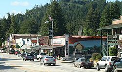
Boulder Creek is a census-designated place (CDP) in Santa Cruz County, California, with a population of 4,923 as of the 2010 census.
Contents
- 130 fairview ave boulder creek california 95006
- Map of Boulder Creek CA 95006 USA
- Geography
- 2010 Census data
- 2000 Census data
- Government
- Notable people
- References
Map of Boulder Creek, CA 95006, USA
Boulder Creek served as the upper terminus of the San Lorenzo Valley Logging Flume terminating in Felton, which began construction in 1874 and when formally opened in October 1875 was augmented by a new rail line to transport logs to the wharf in Santa Cruz. In the 1880s, this lumber town which was called Lorenzo took the name of the Boulder Creek post office that had been established in the 1870s.
Geography
Boulder Creek is located at 37°7′30″N 122°7′30″W (37.125, -122.125).
According to the United States Census Bureau, the CDP has a total area of 7.5 square miles (19 km2).
Boulder Creek is the gateway town to Big Basin Redwoods State Park, which is California's oldest State Park, founded in 1902.
2010 Census data
The 2010 United States Census reported that Boulder Creek had a population of 4,923. The population density was 655.4 people per square mile (253.0/km²). The racial makeup of Boulder Creek was 4,429 (90.0%) White, 54 (1.1%) African American, 31 (0.6%) Native American, 81 (1.6%) Asian, 5 (0.1%) Pacific Islander, 119 (2.4%) from other races, and 204 (4.1%) from two or more races. Hispanic or Latino of any race were 366 persons (7.4%).
The Census reported that 100% of the population lived in households.
There were 2,124 households, out of which 548 (25.8%) had children under the age of 18 living in them, 997 (46.9%) were opposite-sex married couples living together, 176 (8.3%) had a female householder with no husband present, 97 (4.6%) had a male householder with no wife present. There were 189 (8.9%) unmarried opposite-sex partnerships, and 29 (1.4%) same-sex married couples or partnerships. 598 households (28.2%) were made up of individuals and 129 (6.1%) had someone living alone who was 65 years of age or older. The average household size was 2.32. There were 1,270 families (59.8% of all households); the average family size was 2.80.
The population was spread out with 884 people (18.0%) under the age of 18, 319 people (6.5%) aged 18 to 24, 1,222 people (24.8%) aged 25 to 44, 2,066 people (42.0%) aged 45 to 64, and 432 people (8.8%) who were 65 years of age or older. The median age was 45.4 years. For every 100 females, there were 105.2 males. For every 100 females age 18 and over, there were 104.3 males.
There were 2,455 housing units at an average density of 326.8 per square mile (126.2/km²), of which 71.6% were owner-occupied and 28.4% were occupied by renters. The homeowner vacancy rate was 2.1%; the rental vacancy rate was 6.5%. 74.0% of the population lived in owner-occupied housing units and 26.0% lived in rental housing units.
2000 Census data
As of the census of 2000, there were 4,081 people, 1,630 households, and 1,025 families residing in the CDP. The population density was 963.3 people per square mile (371.6/km²). There were 1,829 housing units at an average density of 431.7 per square mile (166.6/km²). The racial makeup of the CDP was 90.25% White, 0.59% African American, 1.10% Native American, 1.72% Asian, 0.20% Pacific Islander, 2.18% from other races, and 3.97% from two or more races. Hispanic or Latino of any race were 5.68% of the population.
There were 1,630 households, of which 31.8% had children under the age of 18 living with them, 48.1% were married couples living together, 10.1% had a female householder with no husband present, and 37.1% were non-families. 25.6% of all households were made up of individuals and 4.2% had someone living alone who was 65 years of age or older. The average household size was 2.50 and the average family size was 3.02.
In the CDP, the population was spread out with 23.6% under the age of 18, 7.9% from 18 to 24, 33.8% from 25 to 44, 28.7% from 45 to 64, and 6.0% who were 65 years of age or older. The median age was 38 years. For every 100 females there were 101.1 males. For every 100 females age 18 and over, there were 101.6 males.
The median income for a household in the CDP was $60,455, and the median income for a family was $66,037. Males had a median income of $48,125 versus $40,197 for females. The per capita income for the CDP was $32,012. About 1.9% of families and 8.0% of the population were below the poverty line, including 0.9% of those under age 18 and 7.4% of those age 65 or over.
Government
In the California State Legislature, Boulder Creek is in the 17th Senate District, represented by Democrat Bill Monning, and in the 29th Assembly District, represented by Democrat Mark Stone.
In the United States House of Representatives, is in California's 18th congressional district, represented by Democrat Anna Eshoo.
The Boulder Creek area is represented on the Santa Cruz County Board of Supervisors by Bruce McPherson.