
 | ||
Glorieta bosques de las lomas prueba 4k
Bosques de las Lomas is a colonia, or officially recognized neighborhood, located in western Mexico City. It falls partly in Cuajimalpa borough and partly in Miguel Hidalgo borough.
Contents
- Glorieta bosques de las lomas prueba 4k
- Map of Bosques de las Lomas Mexico City CDMX Mexico
- Demographics
- Jewish community
- Economy
- Education
- Transportation
- References
Map of Bosques de las Lomas, Mexico City, CDMX, Mexico
The neighborhood is bordered by:
Demographics
According to INEGI, in 2005, 24,552 people lived in the part of Bosques located in the Miguel Hidalgo borough.
Jewish community
In the 1950s, 60s, and 70s, the majority of Mexico City's Jews moved from Condesa, Roma and the Downtown to Polanco, Lomas de Chapultepec, Interlomas, Bosques de las Lomas, and Tecamachalco, where the majority are now based.
Economy
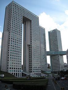
The Arcos Bosques office and shopping complex is located in the neighborhood, just east of the beginning of the Santa Fe district, Mexico City's new financial district.
The most exclusive places are located in this area.
Education
Private schools:
Transportation
Main roads in the neighborhood are Bosque de la Reforma, Paseo de los Ahuehuetes Sur, Paseo de los Tamarindos, and Paseo de los Laureles.
As this is one of the most expensive and exclusive areas of Mexico City, public transportation is relatively poor, with only a few bus routes and expensive taxi services available. Car ownership is very high among residents, and they are rarely seen walking the streets.