
Primary outflows River Kurkureuk Max. width 3.9 km (2.4 mi) Surface elevation 321 m Shore length 13.6 km | Max. length 4.5 km (2.8 mi) Surface area 11 km (4.2 sq mi) Area 11 km² | |
 | ||
Location Akmola Region, Kazakhstan (near Kokshetau) Primary inflows | ||
borovoe kazakhstan
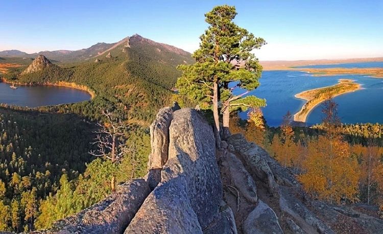
Borovoe (Бурабай көлі) is one of the Burabay lakes in the north of Kazakhstan, in the Burabay District of Akmola Region, in the eastern foothills of Kokshe Mountain.
Contents
- borovoe kazakhstan
- Map of D091D0BED180D0BED0B2D0BED0B5 020000 Kazakhstan
- Shchuchinsk borovoe dji phantom drone footage
- Naming
- In literature
- References
Map of %D0%91%D0%BE%D1%80%D0%BE%D0%B2%D0%BE%D0%B5, 020000, Kazakhstan
Shchuchinsk borovoe dji phantom drone footage
Naming
The shores of the lake are overgrown with pine forest. The name of the lake originates from the word bor, which means "pine forest". The historical name is Auliekol, which means "holy lake". The water in the lake is limpid and the bottom can be seen clearly. The water surface of the lake is almost open, only the western and northwestern shores are rushy; the southern shores are rocky, and the eastern shores are sandy. The bottom is flat.
The lake has several capes. Near the northwestern cape, there is a rocky mushroom-shaped island, Zhumbaktas ("Sphinx"), reaching an elevation of 20 metres (66 ft) above the water. Borovoe is separated by mountain ranges from the closest lakes. The cliffs and capes of the northwestern and southern coasts create a unique landscape.
The lake is situated within Burabay National Park. The lake water is healing. On the eastern shore, there is the Burabay medical resort and the Nature Museum (Kazakh: Табиғат мұражайы).
In literature
The Kazakh writer Zhanaidar Musin, in his book «Жер шоктыгы Кокшетау» (Almaty, 1989), called Lake Borovoe "Kumuskol", which means "silver lake". The nature of Borovoe is proclaimed in Saken Seifulin’s poem “Kokshetau”: