
Elevation 97 m (318 ft) Time zone CET (UTC+1) Local time Thursday 1:21 PM Dialling code 0583 | Province / Metropolitan city Lucca (LU) Demonym(s) Borghigiani Area 72.2 km² Postal code 55023 | |
 | ||
Frazioni Anchiano, Cerreto, Diecimo, Dezza, Gioviano, Valdottavo, Cune, Corsagna, Tempagnano, Oneta, San Romano, Domazzano, Chifenti. Weather 13°C, Wind S at 13 km/h, 87% Humidity | ||
Borgo a Mozzano is a town and comune in the province of Lucca, in northern Tuscany (Italy), located on the Serchio River.
Contents
- Map of 55023 Borgo a Mozzano Province of Lucca Italy
- History
- Main sights
- Transportation
- Twin towns
- References
Map of 55023 Borgo a Mozzano Province of Lucca, Italy
History
The town is mentioned for the first time in 879, when a document mentioned one place In loco Mozzano prope Decimo. Later it was held by the Soffredinghi family, and then by the Republic of Lucca.
After the end of the Lucchese independence, it was part of the Grand Duchy of Tuscany and, from 1860, of Unified Italy.
Main sights
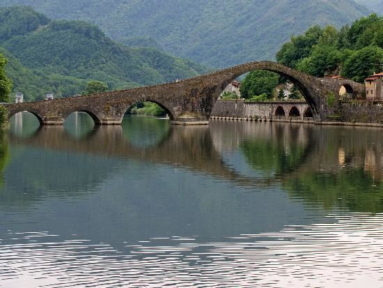
Borgo a Mozzano is dominated by the presence of Ponte della Maddalena also called "del Diavolo" (Devil's Bridge). The Devil's Bridge is located on the SP2 one kilometer north of downtown. The bridge's majestic structure attracts thousands of tourists every year.
Transportation
The town of Borgo a Mozzano is centrally located between the Garfagnana and the Lucchesia, and can be easily reached by car with the SS12 "Brennero" or the SP2 "Lodovica". The nearest major airport (50 min drive) is the Galileo Galilei International Airport of Pisa.
Also, the town has its own train station served by the line Lucca-Aulla. Finally, an efficient bus system connects Borgo a Mozzano with the city of Lucca and the rest of the Garfagnana.