
Elevation 708 m (2,323 ft) Website SFSO statistics Population 123 (31 Dec 2008) | SFOS number 5094 Local time Thursday 1:18 PM Postal code 6658 | |
 | ||
Weather 10°C, Wind S at 6 km/h, 43% Humidity | ||
Borgnone was a municipality in the district of Locarno in the canton of Ticino in Switzerland. On 25 October 2009 the municipalities of Borgnone, Intragna and Palagnedra merged into the municipality of Centovalli.
Contents
Map of Borgnone, Switzerland
History
Borgnone is first mentioned in 1364 as Brugnono'. In the Middle Ages it was part of the Locarno region. In the 15th Century, it became a Degagna, which was part of the bailiwick of Locarno between the 16th Century and 1798. It then became an independent political municipality when the municipality of Centovalli was split in 1838.
It belonged to the parish of Palagnedra and in 1630 became a vice-parish. The Church of Beata Vergine dell 'Assunta (built 1364-65) underwent several transformations.
A strong seasonal emigration supplemented the income from agriculture and animal husbandry of the residents. Since 1964, a small textile factory was built on the border in Camedo. The majority of the population (1990: 70%) is in the services sector, and half of all residences are second or vacation homes. In 1923 the Locarno-Domodossola rail line was completed.
Location
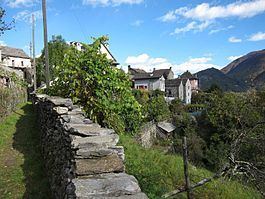
The former municipality is located in the Locarno district, on the northern slope of the Centovalli at an elevation of 708 m (2,323 ft). It is about 200 m (660 ft) above the valley floor. It is located on the border with Italy and includes the fractions Costa, Lionza and the newer settlement of Camedo on the valley floor with a customs and railway station.
Historic population
The historical population is given in the following table: