
Country United States ZIP codes 79834 Elevation 562 m | Time zone Central (CST) (UTC-6) Area code 432 Local time Monday 6:03 PM | |
 | ||
Weather 31°C, Wind W at 10 km/h, 11% Humidity | ||
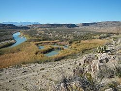
Boquillas was a small settlement in Texas, located on the northern banks of the Rio Grande. It was located within Brewster County, five miles northeast of San Vicente, Texas. The place existed to service the mining operations at Boquillas del Carmen, Mexico, just across the Rio Grande.
Contents
Map of Rio Grande Village, Texas 79834, USA
Boquillas, Texas is now in Big Bend National Park. It is now usually known as Rio Grande Village, and consists of a ranger station and other buildings to serve visitors to the park. In 1916 over 200 Villistas raided Boquillas and nearby Glenn Springs, Texas. At Boqullas the Americans were able to capture one of the raider commanders but lost two men who were taken captive by the Mexicans.
The Rio Grande border crossing to Boquillas del Carmen was closed in 2002. On January 7, 2011, the U.S. National Park Service announced plans to reopen the crossing. After multiple delays, the unmanned border station was finally opened on April 11, 2013.
Geographic Points of Interest
Climate
The Köppen Climate Classification system categorizes Boquillas as a semi-arid climate characterized between an intermediate desert climate and humid climate.