Max. length 0.93 miles (1.5 km) Max depth 46 m Area 21 ha Shore length 5 km | Basin countries England Surface area 52 acres (20.9 ha) Length 1,497 m Catchment area 15.7 km² | |
 | ||
Average depth 5 feet 3 inches (1.6 m) Similar Baitings Reservoir, Scammonden Bridge, Deanhead Reservoir, Scammonden Reservoir, Ryburn Reservoir | ||
Booth wood reservoir yorkshire dji phantom 3
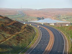
Booth Wood Reservoir is a man-made upland reservoir that lies north of the M62 motorway and south of the A672 road near to Rishworth and Ripponden in Calderdale West Yorkshire, England. The reservoir was approved for construction in 1966 and completed in 1971. It supplies water to Wakefield.
Contents
- Booth wood reservoir yorkshire dji phantom 3
- Map of Booth Wood Reservoir Ripponden Sowerby Bridge UK
- Booth wood reservoir aerial photography
- References
Map of Booth Wood Reservoir, Ripponden, Sowerby Bridge, UK
The reservoir dams the Booth Dean Clough watercourse and takes water directly from the surrounding moorland. It has a plain concrete crest on the dam head which is straight and extends to a length of 1,150 feet (350 m) and a height of 157 feet (48 m).
In 1995 a long dry spell in the summer created a larger than normal abstraction of water from Booth Wood creating the need to transport water into the reservoir as stocks ran very low. Road tankers carrying fresh water were despatched from Selby in North Yorkshire and Kielder Water in Northumberland to bring water for offloading at Booth Wood. At the height of the operation, 700 tankers delivered 70,000 litres of water a day to the reservoir which then fed other reservoirs in West Yorkshire.
On 14 August 2016, the A672 road which runs along the northern edge of the reservoir was closed whilst police searched for a driver and car that had plunged off the road and into the reservoir. The driver was believed to be the only person in the car and the search operation involved helicopters and underwater divers. The search resumed the next day when a man's body was recovered.
