
Canton Bonnieux INSEE/Postal code 84020 / 84480 Population 1,408 (2007) | Time zone CET (UTC+1) Area 51.12 km² Local time Monday 8:01 PM | |
 | ||
Weather 10°C, Wind W at 37 km/h, 42% Humidity Points of interest Pont Julien, Château La Canorgue, La Louve, Foret des cedres, Musée de la Boulangerie | ||
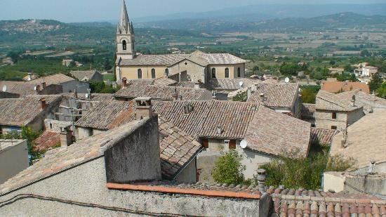
Bonnieux is a commune in the Vaucluse department in the Provence-Alpes-Côte d'Azur region in southeastern France. In the plain below the village stands the notable Roman bridge the Pont Julien.
Contents
Map of 84480 Bonnieux, France
Geography
Bonnieux is one of the many historic "hill villages" in the region. Dating back to Roman times, it rests on top of the Luberon hills casting a watchful gaze across the rest of the valley. Next to the village is a Cedar forest that began with trees imported from North Africa during the Napoleonic era. It sits opposite Mont Ventoux, other notable villages in the area include Ménerbes, Lacoste, Roussillon, and Gordes.
The commune is traversed by the river Calavon.
History
The region has been occupied since neolithic times, with evidence scattered throughout the Luberon. Monuments dating from Roman times exist near the village including the Pont Julien built in 3 BC located only 3 miles to the north. A monastery was first built at that location in the 6th century, and walls were in place by the 10th century. The town reached a maximum population in the mid 19th century, with 2804 people in 1841. It has since declined to less than half its peak with 1363 in 2004.