
Lake type Hyper-Eutrophic Max. width 1.2 km (0.75 mi) Area 3.77 km² Length 5 km Catchment area 49.6 km² | Primary outflows Stony Creek Max. length 5 km (3.1 mi) Surface elevation 648 m Mean depth 3.1 m Width 1.2 km | |
 | ||
Location | ||
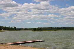
Bonnie Lake is a small lake in Alberta, Canada. It is located 6 km (3.7 mi) outside of Vilna, Alberta, north of Highway 28, and is part of the North Saskatchewan River basin.
Map of Bonnie Lake, Smoky Lake County, AB, Canada
The lake has a surface of 3.77 km2 (1.46 sq mi) and reaches a maximum depth of 6.1 m (20 ft), while the average depth is 3.1 m (10 ft). Bonnie Lake drains a total area of 49.6 km2 (19.2 sq mi). The lake drains through its south shore into Stony Creek which empties into the North Saskatchewan River.
There is a small camp ground with 25 sites, power, and a beach, managed as the Bonnie Lake Provincial Recreation Area. There are very few fish in the lake, but there is a large number of birds on the lake. There is also a small golf course very close to the lake.
References
Bonnie Lake (Alberta) Wikipedia(Text) CC BY-SA