
Amphoe Sai Yok Elevation 300 m | Province Kanchanaburi Time zone Thailand (UTC+7) Population 3,894 (2005) | |
 | ||
Pderm pi leik soun bong ti mouy
Bong Ti (Thai: บ้องตี้) is a village and tambon (subdistrict) of Sai Yok District, in Kanchanaburi Province, Thailand. The tambon contains 4 villages.
Contents
- Pderm pi leik soun bong ti mouy
- Map of Bong Ti Sai Yok District Kanchanaburi 71150 Thailand
- Geography
- References
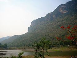
Map of Bong Ti, Sai Yok District, Kanchanaburi 71150, Thailand
Geography
Bong Ti Subdistrict is located in the mountainous area of the Tenasserim Hills, close to the border with Myanmar. There is a tarmac road connecting with Sinbyudaing in Myanmar at the western end of the subdistrict. In 2005 the tambon had a total population of 3,894 people. Many of the local inhabitants are Karen people.
In 2015 sound from the meteor was reported in three districts of Kanchanaburi Province: Thong Pha Phum, Sai Yok and Si Sawat. The Governor of Kanchanaburi Province Wan-chai Osukhonthip ordered police and Sai Yok National Park rangers to search Wang Krachae and Bong Ti subdistricts in Sai Yok District for meteor debris.