
Designated 1997 Length 32 km | Designated 1998 Country Canada | |
 | ||
Official name Dredge No. 4 National Historic Site of Canada Official name Discovery Claim (Claim 37903) National Historic Site of Canada | ||
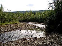
Fall sluicing bonanza creek october 2013
Bonanza Creek is a watercourse in Yukon Territory, Canada. It runs for about 20 miles (32 km) from King Solomon's Dome to the Klondike River. In the last years of the 19th century and the early 20th century, Bonanza Creek was the center of the Klondike Gold Rush, which attracted tens of thousands of prospectors to the creek and the area surrounding it. Prior to 1896 the creek was known as Rabbit Creek. Its name was changed by miners in honor of the millions of dollars in gold found in and around the creek.
Contents
- Fall sluicing bonanza creek october 2013
- Map of Bonanza Creek Yukon Unorganized Yukon Canada
- Bonanza creek ceo gushing over revenue
- References
Map of Bonanza Creek, Yukon, Unorganized, Yukon, Canada
During gold-mining operations, the course of the creek changed drastically. It was heavily developed during the early 20th century, but was largely abandoned by the 1950s. A handful of small gold-mining operations continue on the creek, but today it is best known for its historic value. Two National Historic Sites of Canada have been designated along the creek: