
 | ||
Paddle boarding bolinas lagoon gopro time lapse
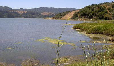
Bolinas Lagoon is a tidal estuary, approximately 1,100 acres (4.5 km2) in area, located in the West Marin region of Marin County, California, United States, adjacent to the town of Bolinas. It is a part of the Greater Farallones National Marine Sanctuary and is considered to be among the possible landing spots of Sir Francis Drake on the west coast of North America in 1579.
Contents
Map of Bolinas Lagoon, California 94924, USA
The lagoon is a back bay of Bolinas Bay on the Pacific coast approximately 15 mi (25 km) northwest of San Francisco. The trough in which the lagoon sits was formed by the San Andreas Fault, which runs directly through it. The lagoon is separated from the main bay by a small spit of land, known as Stinson Beach, and the sand bar that encloses this lagoon is full of beachgoers and surfers on hot days, seeking to escape the heat and the urban Bay Area. State Route 1, the Shoreline Highway, runs along the eastern edge of the lagoon.
Bolinas Lagoon is on the list of wetlands of international importance as defined by the Ramsar Convention for the conservation and sustainable utilization of wetlands. Portions of the lagoon are included in Bolinas Lagoon County Park, and the western shore is part of the Golden Gate National Recreation Area.
The lagoon has a 16.7-square-mile (43 km2) watershed; streams and canyons feeding into it include Audubon Canyon, McKinnan Gulch, Morses Gulch, Picher Canyon, Pike County Gulch, Stinson Gulch, Volunteer Canyon, and Wilkins Gulch. Kent Island is located in the lagoon.
Duxbury Reef State Marine Conservation Area lies offshore from Bolinas. Like an underwater park, this protected marine area helps conserve ocean wildlife and marine ecosystems.