
Elevation 613 m | Mountain range Haardt | |
 | ||
Parent range Haardt, Palatine Forest Similar Kesselberg, Hochberg, Roßberg, Schafkopf, Hohe Loog | ||
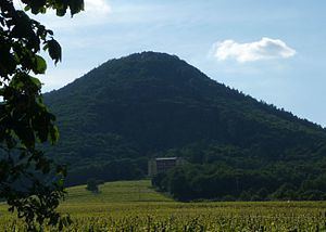
The Blättersberg near Rhodt unter Rietburg in the Rhenish-Palatine county of Südliche Weinstraße is a mountain, 613.2 m above sea level (NHN), in the Palatine Forest in the German state of Rhineland-Palatinate.
Contents
- Map of BlC3A4ttersberg 76835 Rhodt unter Rietburg Germany
- LocationEdit
- ElevationEdit
- Ludwig TowerEdit
- Transport linksEdit
- References
Map of Bl%C3%A4ttersberg, 76835 Rhodt unter Rietburg, Germany
The mountain has a north summit (613.2 m) and a south summit (606 m); on the latter is the Ludwig observation tower.
LocationEdit
The Blättersberg lies in the Haardt, the eastern mountain chain of the Palatine Forest, in the eponymous nature park. Its summit rises 3 kilometres west-northwest of Rhodt unter Rietburg, within whose territory most of the mountain lies, 4.5 km west-southwest of Edenkoben, between the Edenkoben valley in the north and the Modenbach valley in the south, and 1.6 km (all as the crow flies) northwest of the village of Weyher in der Pfalz. The mountain can be clearly made out from the Rhine Plain. On its east-northeastern flank, to the west and above the stately home of Villa Ludwigshöhe that is visible for miles, is the castle of Rietburg (Rhodt), which is also a landmark. At the southern foot of the mountain, by the upper reaches of the Modenbach stream, lies the historic estate of the Buschmühle mill.
ElevationEdit
The elevation of the Blättersberg is given on some topographic maps as 613.2 m, but on others as 618 m. About 60 metres south-southeast of the summit is another high point, 611.8 m.
Ludwig TowerEdit
On the southern summit of the Blätterberg stands an observation tower, built in 1883, called the Ludwig Tower (Ludwigsturm). From the viewing platform of the 15 metre-high tower the view to the east into the Rhine Plain is blocked by the trees, but elsewhere one can see as far as the Badener Höhe and Hornisgrinde in the Black Forest to the south-southeast, nearby Trifels Castle to the southwest, the Frankenweide forest with its hills, the Weißenberg (Luitpold Tower) and Hortenkopf (transmission mast) to the west, the nearby Kesselberg mountain to the northwest and the highest point in the Palatine Forest, the Kalmit, to the north-northeast.
Transport linksEdit
The Blättersberg and the Ludwig Tower may be reached from the top station of the chair lift near Villa Ludwigshöhe (530.8 m) or from the Hüttenbrunnen hiker's car park in the Edenkobener valley above the Kohlplatz. Numerous hiking trails run through the local countryside.