
Type Reservoir Surface elevation 412 m Mean depth 28 m Catchment area 227.9 km² | Primary inflows Max. length 6.4 mi (10.3 km) Area 3.784 km² Length 10.3 km Inflow source Blue River | |
 | ||
Surface area 935 acres (378 ha), 1,420 acres (570 ha) when full | ||
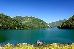
Blue River Reservoir is an artificial impoundment, about 6 miles (10 km) long, of the Blue River in Lane County in the U.S. state of Oregon. The reservoir is about 1 mile (1.6 km) north of Oregon Route 126 in the Willamette National Forest about 45 miles (72 km) east of Eugene.
Contents
Map of Blue River Reservoir, Oregon 97413, USA
In 1968 the United States Army Corps of Engineers built Blue Lake Dam and Saddle Dam about 2 miles (3.2 km) from the mouth of the Blue River on the McKenzie River to create a reservoir for flood control and irrigation. Despite frequent blooms of blue-green algae, the lake is heavily used for recreation. Trout are the principal fish, supplemented from local hatcheries.
Recreation
Blue River Reservoir is used for fishing, boating, swimming, and waterskiing. The United States Forest Service manages Mona Campground, on the north side of the reservoir, and Lookout Campground, on the northeast side. The Forest Service also manages two launching sites for motorized and non-motorized boats, one near Lookout Campground and the other near Saddle Dam on the south shore. The reservoir supports populations of native coastal cutthroat trout and stocked rainbow trout.