
Other name(s) Adelmannsfelden Rot River system Rhine Country Germany | State Baden-Württemberg Length 28 km | |
 | ||
Main source Near Vorderuhlberg, Frankenhardt municipality
c. 503 metres (1,650 ft) River mouth Kocher, near Schäufele, Abtsgmünd municipality
c. 363 metres (1,191 ft) Progression Kocher → Neckar → Rhine → North Sea | ||
The Blinde Rot is a river in Baden-Württemberg, Germany.
Contents
- Map of Blinde Rot Germany
- GeographyEdit
- TributariesEdit
- Environment Protected AreasEdit
- FaunaEdit
- FloraEdit
- Water qualityEdit
- HistoryEdit
- Things BuildingsEdit
- EconomicsEdit
- Importance as a transport routeEdit
- References
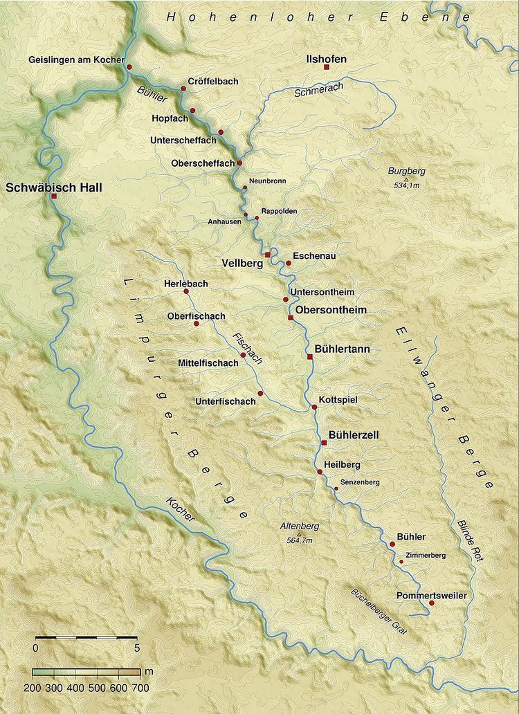
Map of Blinde Rot, Germany
The Blinde Rot, also Adelmannsfelden Rot, is a river in the Ellwangen mountains in northern Baden-Württemberg, that springs on the territory of the municipality Frankenhardt and glows on the municipality Abtsgmünd in the Kocher.
GeographyEdit
The Blinde Rot springs on the pebbly sandstone plateau on the northern foothills of the Ellwangen mountains, flows soon through the Fleckenbachsee and then runs in the valley south, about 2 km from the mouth of Hornberg (Abtsgmünd) to turn abruptly to the west and then to achieve in the Kocher.
The valley lies over the entire length in the middle Keuper. The west as east approximately parallel and larger neighboring rivers Bühler and Jagst both flow in opposite directions to the north.
TributariesEdit
The tributaries of the Blinde Rot are listed from source to mouth:
Environment, Protected AreasEdit
The Blind Red extends in a first very shallow ravine which from about Willa deepens stronger and nowhere exceeds a maximum width of 150 m. Mostly enclosed on both sides by wooded slopes, a small-scale, natural river landscape has been preserved on the valley floor. Pastures alternate here with wooded lots from, including elsewhere rare alder, by both the river meanders freely in natural meanders with steep and flat slopes, accompanied by sandbanks, oxbow lakes and slowly silted pools. In the upper reaches the valley is from the community Bühlerzell to the hamlet Grafenhof designated as conservation area. The area formed by ordinance by the district office Ostalbkreis of 5 May 1994 is 358 hectares. Immediately thereafter till the Burghardmühle below Adelmannsfelden is the protected landscape valley of the Blinde Rot. It covers 84.5 hectares and was disclosed already on 20 December 1968.
FaunaEdit
The reserve Valley Blind Red is a habitat with a rich fauna. In the valley 28 breeding bird species were observed, including the White-troated dipper, the Common kingfisher, the Eurasian woodcock and the Marsh warbler. The reptiles are represented with Viviparous lizard and Anguis fragilis. Of the 7 species of amphibians are for example the Fire salamander and the Yellow-bellied toad. In the water of the Blinde Rot live the rare brook trout and the endangered brook lamprey, and on the floodplain of the creek fly many butterflies and dragonflies.
FloraEdit
Along the shore of the blind red are Alnus glutinosa and willows. In the extensively farmed wetlands still growing Trollius eurpaeus. In the wetlands to find the source bulrush and various sedges like the Yellow, the tassel visible, the felt and the fox sedge. An orchid that come Broad, the meat red and the rare green-winged orchid in the valley before, else the yellow aconite and the forest-Columbine.
Water qualityEdit
The blind was red with 2004 levels detected over her for this run from about the inflow of Geißbachs lightly loaded (class I-II).
HistoryEdit
In the catchment area, which is more than half covered by forests, the forest industry was formerly predominantly with charcoal burners, resins, and especially the extraction of timber. It was processed in sawmills into sawn timber, but was above all a source of energy, to be instilled as firewood to the valley. Lots of the wood from the forests was brouht via blind Red and Kocher Schwäbisch Hall where the saline resistant had a great need for firewood.
Things BuildingsEdit
EconomicsEdit
Formerly used in the valley of the blind red water power to drive some sawdust, paper and oil mills. There is still a small saw-mill on Betzenhof. On the Ludwigsmühle below Willa is an average operating woodworking. At four locations in the valley hydropower is still used today.
Importance as a transport routeEdit
In the valley, there are along the river hardly roads. In addition to the L 1060 Willa and the L 1073 in Adelmannsfelden are no maintained roads of more than local significance.