
Type natural Primary outflows Blelham Beck Max. width 0.257 km (0.160 mi) Surface elevation 47 m Residence time 2 months | Etymology dark blue pool Max. length 0.66 km (0.41 mi) Surface area 11 ha (27 acres) Area 11 ha Outflow location Blelham Beck | |
 | ||
Lake district country walk hawkshead outgate to blelham tarn and wray castle round
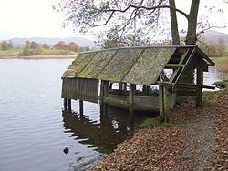
Blelham Tarn is a large valley tarn in the Lake District to the north of the hill Latterbarrow. The settlements of Outgate, Low Wray and High Wray are close by. The tarn is drained to the northeast by the short Blelham Beck into Windermere. This beck was previously straightened and lowered. Fish species in the tarn include brown trout, eel, perch, pike and roach, much of the tarn shore is reedbed and waterfowl present can include great crested grebe, whooper swan and golden-eye.
Contents
- Lake district country walk hawkshead outgate to blelham tarn and wray castle round
- Map of Blelham Tarn Ambleside UK
- References
Map of Blelham Tarn, Ambleside, UK
The tarn is regularly monitored by the United Kingdom Lake Ecological Observatory Network and is characterised as eutrophic and monomictic and has suffered from agricultural water pollution with large quantities of blue-green algae in the summer. The lake temperature at various depths varied over the period July 2012 to November 2014 between 2 and 25 Celsius as the air temperature (3 m above the surface) varied between -3 and 22 Celsius. Over the same period the pH varied from 6.4 to 9.8 and the dissolved oxygen ranged from 7 to 14 mg/l
Blelham Tarn and Bog, with a total area of 49 hectares, is designated a site of special scientific interest and Blelham Bog is designated a National Nature Reserve The bog contains various species of sphagnum moss, bog myrtle, cotton-grass and the white-beaked sedge; and rare caddis-flies and vertigo lilljeborgi.